Saturday, August 18, 2012

Olympic National Forest - Mt. Zion

After my first hike in Olympic National Park (ONP) at Hurricane Ridge, I picked up a book in the visitor center gift shop, Best Easy Day Hikes - Olympic National Park.  It's a handy little Falcon Guide.  Both this guide and the Best Hikes with Kids - Western Washington & the Cascades list Mt. Zion as a challenging but rewarding day hike.  So it's been on my Washington Bucket List ever since.


I wasn't sure if my boys would be able to tackle this one.  The Best Hikes with Kids books has a 3-point difficulty rating scale and gave this one the most difficult of their three ratings.  Thanks to a friend's birthday party invitation, the opportunity arose for me to go tackle Mt. Zion on my own without the boys.

My hiking partner and I left Silverdale a little after 7 a.m. and arrived at the Quilcene Ranger Station just before they opened at 8 a.m. to get our annual pass (free to military).  On our way driving over, I was alarmed at how the Hood Canal Bridge was socked-in really dense fog.  I mean, we couldn't see a hundred yards in front of us as we drove across the bridge.  The forecast called for a sunny day, so I was hopeful it would burn off by the time we got up to the summit of Mt. Zion.  As we climbed into the mountains from the Quilcene Ranger Station, we drove out of the fog and into the bright sunlight at around 1,300 feet of elevation.

The roads aren't very well marked, and we encountered one family that was lost and asked us for directions.  If you don't have a GPS to show you where you are on the map, I recommend studying the map before you go so you can anticipate the turns.  The driving directions in both guide books and the WTA website were fair enough.

When you get to the trailhead, you'll know.  It's fairly obvious with a small parking lot, a picnic table, and a "privy" / men's and women's dual outhouse.  We departed the parking lot at 9:09 a.m.

The trail is fairly steep and does a lot of switchbacks up the hill, but at no point do you need any ropes or anything to get up the trail.  I was breathing hard all the way up.  For comparison, I logged almost exactly the same number of miles on this hike as the Hurricane Hill hike up at Hurricane Ridge (3.84 vs 3.86 miles), but this one came with an extra 555 feet of elevation gain (900 feet vs 1455 feet).

View northeast from the summit - solid fog.


The summit was a little anticlimactic.  As described in guide books, the view to the southwest toward the Olympics is obscured by trees.  Sadly, the fog didn't burn off, so our view to the northeast toward Port Townshend was a sea of white.

Trip Stats at the Summit

Both guide books I mentioned above only describe hiking to the summit.  I am thankful for the Washington Trails Association web page that described hiking an additional half mile southeast from the summit to a ledge with better views.

View from the rock ledge 0.5 miles SE of the summit.


Note there are three different trails heading off in different directions from the summit, so I broke out the compass and chose the trail that headed southeast.  Even then, that wasn't sufficient to get us to the ledge.  There was a fork in the trail where we had to make a decision.  We went LEFT and we got lucky.  That was the right path to get to the rocky ledge.  The view from the ledge was spectacular and worth the extra half mile hike.

Don't look down...

All the guides and reviews I've read about this hike say it is spectacular in July with all the rhododendrons in bloom.  I believe them.  There were rhodies everywhere.  Although the rhodies weren't in bloom, there were many other flowers along the trail, and I continue to be amazed with the new flowers I see every time I go hiking in Washington.  Here are some of the new flowers I saw on this hike:

Bunchberry - this was my favorite from this hike.  Very pretty.

Pearly Everlasting

Pipsissewa

These look sort of like foxglove, but they were laying flat on the ground instead of in tall stalks.  I can't find anything like it in my book of Pacific Northwest flowers.  Any help?

These purple stalks were EVERYWHERE.
I think it's Broadleaf Lupine.

 Twin Flower

There was a lot of this near the overlook.  I think it's Oceanspray.

Is this Scotchbroom?  There were small spots of it around the parking lot.  I've seen the walls of yellow on either side of the highways around Silverdale and heard that it is Scotchbroom, but I guess I've never gotten out of the car to go look at it close up.  Scotchbroom is the only thing I can match it to in my flower book.


Speaking of which, I really like this book a lot.  It's well organized and has decent pictures.

Overall, in spite of the disappointing view at the summit and logging a DNF on the geocache there, the view from the rocky ledge and the flowers along the way made it an excellent hike.  I'm very glad to have had this glorious Saturday to spend getting some exercise and enjoying the beauty of Olympic National Forest. 

Hike Stats:  When I'm searching for places to hike with my kids, I appreciate having some basic facts and figures about the hike for me to judge if it's doable with my kids.  With that in mind, I hope other parents considering this hike find the following information useful. Note:  This is hike #161 on page 402 of Best Hikes with Kids - Western Washington & The Cascades, and the book gives this hike the most strenuous rating on their 3-point scale.  I had seen pictures online of other families doing this hike with middle-school aged children, but I thought it best to leave my boys at home for this one.
  • Date: 18 August 2012
  • Time of Departure: Left house in Silverdale at 7 a.m. and arrived at the Quilcene Ranger Station to get my park pass right when they opened at 8 a.m.  Departed the trailhead at 9:09 a.m. 
  • Time of Return: 12:31 p.m. back in car at trailhead.  Drove directly home with no stops, arrived home at 2 p.m. on the nose.
  • Elapsed:  3 hours 22 minutes
  • Moving Time (GPS):  1 hour 56 minutes 
  • Stopped Time (GPS):  1 hour 26 minutes 
  • Mileage (GPS): 3.86 miles
  • Avg Speed (GPS):  2.0 mph
  • Elevation Gain:  1455 feet
  • Max Elevation:  4273 feet
  • Weather:   Hood Canal was fogged in.  As we ascended into the mountains, we broke out into the sunlight around 1,300 feet or so.
  • Winds:  < 5 mph W, but I didn't really notice even the slightest breeze while we were hiking.
  • Air Temp: In Quilcene it was 57F climbing to 64F.  I was very comfortable in a t-shirt and shorts and was pretty sweaty when we got back to the car.
  • Trail:  Well-defined hard-pack dirt trail.  No trail markers, and there were a few spots where there were forks in the trail and we guessed which way to keep going.  
  • Crowds?  Not crowded, but not alone.  We encountered one family of 4 at the summit and a boyfriend/girlfriend couple who came RUNNING up the trail to the summit while we were there and RAN past us on our way back down.  Did I mention I was almost out of breath just WALKING up the trail???  Also on our way back down, we passed three other small groups on their way up the trail.  We were the first car in the parking lot that morning, but when we got back there were about 6 cars there.
  • Hazards?  Some steep dropoffs.  I've heard to beware the mountain goats that can be aggressive in ONP, but we didn't see or hear of any on Mt. Zion.
  • Geocaches?   Searched for the one geocache at the summit, but logged a DNF.
  • Kit: T-shirt, shorts, hiking boots, flop hat, walking stick.  We were under the shade of trees most of the time and didn't need sun screen much.  There were a fair amount of flying bugs, but I didn't see any mosquitoes.
  • Route:  There is a picnic table and a privy at the trailhead parking lot, but I did not see any sources of water.  Note!  You need a U.S. Forest Service Northwest Forest Pass or Interagency annual pass (i.e. a National Park Annual Pass) to display on your windshield in this parking lot.  None of our guide books told us that.  You can pick one up at the Quilcene Ranger Station.  Our guide books only mentioned hiking to the summit of Mt. Zion.  Thanks to the Washington Trails Association website, we read about hiking southeast a half mile past the summit to an area with a better view.  At the summit, there were three trails going off in different directions, so we used our compass to tell which one was headed southeast per the WTA description and took that trail.  Then, a little ways along, there was a pretty substantial fork in the trail, and both the left and right sides appeared well-traveled.  We chose the LEFT fork and got lucky.  We found the rocky shelf with the spectacular view.  
  • Facilities:  There is a privy and picnic table at the trailhead, but no source of water that I saw.

Sunday, August 12, 2012

Paddle Log #28 Belfair, WA

It was a spectacularly gorgeous weekend here in Kitsap County.  We took advantage of the rare combination of me being home, having the day off, and the nice weather to get our kayaks in the water for the first time this year.  Two places have been on my "places I want to paddle next" list - the Dosewallips Nature Preserve across Hood Canal off of Dabob Bay, and the nature preserve near Belfair at the very end of Hood Canal. 

I opted for Belfair this time since it was a shorter drive.  Low and behold, there was some sort of town festival going on in Belfair that had the main road we wanted to take closed and caused bottleneck traffic on all the side streets to get around it. 

Even so, things worked out pretty well.  We stopped at a little country-cooking type of local place, Pat's Little Red Barn, and picked up some lunch to go.  We took it down and ate lunch on the picnic benches at Belfair State Park.  The food was excellent and the setting couldn't have been much better.

Belfair State Park was a nice place with campgrounds, picnic areas, public restrooms, showers, and obviously beach access.  I was a little surprised that on such a beautiful Saturday, the parking lot here wasn't more than about 10% full.  It does cost $10 per day to use the park or $30 per year if you buy the Washington State Discover Pass.

It's about a hundred yards from the parking lot to the water.  The entry was smooth round rocks and pebbles, so not too hard on the feet.  It's a very shallow incline, and I could see people walking out in the water another hundred yards off shore, so I imagine at low tide it would be a bit longer walk.

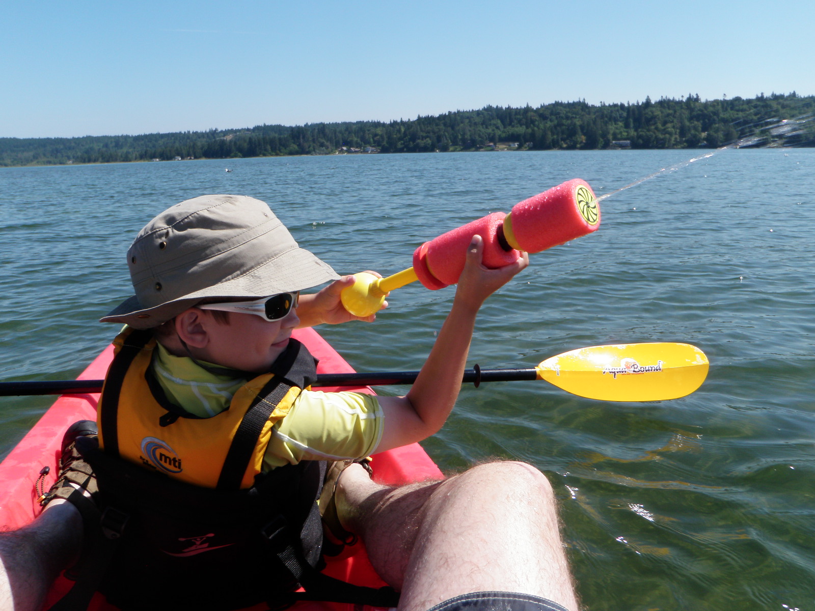
We brought water cannons this time, and the resultant water battle between our two kayaks came with big smiles and deep dimples.

My gunner returning fire.  We had a little bit of an advantage having one person to paddle while the other manned the water cannon.  I was pretty proud of my eldest for how fiercely he was alternating between paddling and shooting.  It kept him distracted.  He paddled for 41 minutes before deciding to take a break and ask for me to hook up our tow line.

We took a break from the water war and tried to keep the noise down while we paddled around the nature preserve.  The waterproof doodle pad proved a hit again.  Here my son is drawing a picture of the two of us in our kayak being eaten by a shark.  Lovely.

On the way back, I handed the camera off to my eldest.  This was his photo from the receiving end of our barrage. 

The water was pretty warm (73F) and shallow, so the boys opted to get out and swim in about the last hundred yards to the beach.

My youngest had put up a stink about not wanting to go kayaking, but my wonderful wife offered him the choice of kayaking with Daddy or helping Mommy clean his room.  He quickly decided to go with me.  In the end, standing here on the beach, he declared, "This was fun.  We should do this more often." 


Stats for the paddle log:
  • Date: Saturday, 11 August 2012
  • Time In: 1:00 p.m.
  • Time Out: 3:10 p.m. (based on time-stamps on my camera)
  • Elapsed:  2 hrs 6 min (based on GPS)
  • Moving Time (GPS): 1 hours 58 min
  • Stopped Time (GPS):  8 min
  • Mileage (GPS): 3.25 miles
  • Sea State: 0.
  • Winds: 7-10 kts NE
  • Air Temp:  75F climbing to 81F
  • Water Temp: 73F
  • Current:  None.
  • Tides: Started on a flood.  High Tide was 9.5 ft at 3:08 p.m.
  • Avg Speed (GPS):  1.6 mph
  • Max Speed by (GPS):  5.1 mph
  • Rapids?  None. 
  • Hazards?  Not much.
  • Kit: My youngest son and I in our Ocean Kayak Malibu Two XL, and my eldest son in his Perception Acadia Scout.  Flop hat, NRS paddling gloves, short sleeve shirt, swim trunks, Keen Newport sandals.
  • Configuration:
  • Route:  Put-in at the Belfair State Park and paddled northeast toward the nature preserve in Belfair.  
  • Other comments (such as wildlife spotted): 5 Great Blue Herons, lots of ducks and geese.

Tuesday, July 31, 2012

Paddle Log #27 Newfound Lake

We took a day trip over to visit my wife's aunt and uncle on Newfound Lake.  As I mentioned in my last post, I didn't have my kayak since we flew across country. 

Conveniently enough, the NH Audubon Society rents kayaks at the Paradise Point Nature Center.  The staff there was very friendly and helpful.  The process of renting the kayak was very quick and painless, and the rates they charge are very reasonable - probably the least expensive kayak rental I've ever had (and I've rented kayaks at two places in Pearl Harbor, on Maui, in DC, and Lake Winnipesaukee before this).  Lemme tell ya it was money well spent, because I had a beautiful afternoon on the water!

The rental gear was in good condition.  They set me up in a single-seater Perception kayak.  Like the loaner Wilderness Systems Pamlico 100 I used a few days ago on Lake Winnipesaukee, it was a little on the small side for me, and my knees were sticking up out of the cockpit, but it wasn't bad. 

I paddled out onto the lake and it was pretty darn choppy.  There was 5-10 knots of wind coming out of the south, and the fetch was allowing the wind waves to build up to 2 feet or so.  I paddled south and then west, clockwise around Paradise Point and into the Charles L. Bean sanctuary.  In the picture above, my boys are speeding by in that boat crossing my bow on their way out tubing.  There's also a family of mergansers in the foreground on the left.

Once I entered the shelter of the sanctuary, it was absolutely peaceful and the water was like glass.  I almost felt guilty disturbing the peace as I glided through the lily pads.  I would have loved to just hang out there a while, quietly gliding along the shore.  Unfortunately, the only downside of renting a kayak from the NH Audubon Society is that they all have to be turned in by 4 p.m., and I still had to paddle up-wind to get back to the dock at Paradise Point.  As a result, you'll see in my trip stats that I was moving for 1 hour 11 minutes but only spent 32 seconds not moving.  Even so, it was still money well spent, good exercise, and a beautiful afternoon on the water. 

When I got back, I was pleasantly surprised to find that family of mergansers sitting on the rocks, and they actually cooperated with letting me try to take some pictures as I paddled by.

Stats for the paddle log:
  • Date: Tuesday, 31 July 2012
  • Time In: 2:36 p.m.
  • Time Out: 4:00 p.m.
  • Elapsed:  1 hrs 11 min
  • Moving Time (GPS): 1 hours 11 min
  • Stopped Time (GPS):  32 seconds
  • Mileage (GPS): 2.87 miles
  • Sea State: 1 on lake, 0 in sanctuary.  There were ~2 foot waves on the lake with a steady wind from the south and plenty of fetch.  Once I paddled into the sanctuary the water was like glass.
  • Winds: 5-10 kts SE
  • Air Temp:  81F
  • Water Temp: 79.4F
  • Current:  None.
  • Gauge Height: 
  • Avg Speed (GPS):  2.4 mph
  • Max Speed by (GPS):  4.5 mph
  • Rapids?  None. 
  • Hazardes?  Not much.  Wake from an occasional passing boat.
  • Kit: Perception rented from NH Audubon Society.  Flop hat, NRS paddling gloves, short sleeve swim shirt, swim trunks, Keen Newport sandals.
  • Configuration:
  • Route:  Put-in at the Paradise Point Nature Center run by the NH Audubon Society.  Paddled clockwise (south then west) around Paradise Point into the Charles L. Bean Sanctuary.  
  • Other comments (such as wildlife spotted): 1 adult merganser with 4 juveniles in tow, many ducks, water bugs and water lilies.


Saturday, July 28, 2012

Paddle Log #26 Lake Winnipesaukee

Since we flew across country for this vacation, we didn't have our own kayaks with us.  My eldest wanted to go kayaking with me, so we packed a picnic lunch and headed on up to Trexler's Marina to rent a tandem kayak.  I also figured this would be a good opportunity to scout out some of the islands and coves on the other side of the island that I didn't reach on my previous solo paddling excursion.

Time stamp leaving Trexler's


Trexler's rents a few different types of kayaks.  We opted for an Emotion Kayak that was essentially the same as our Ocean Kayak Malibu Two XL, but with built-in cupholders.  The staff at Trexler's were very friendly and helpful.  It was expensive though.  The price was the highest I've ever seen for kayak rentals, but I was willing to pay it for one day out on the water with my eldest and for the convenience of it being so close to our condo on the lake.


Lunch Break


From Trexler's, we paddled under the bridge going to Moultonborough Neck bridge to Long Island and on to the east following the shoreline counterclockwise into a small cove.  We stopped to have lunch there in the cove, and found ourselves surrounded by two families of loons.  There were somewhere between 6 and 8 loons, but I couldn't count them all because they kept diving underwater.

Loon off the starboard bow

As we continued our paddle along the shoreline, at one point we startled and were startled by a Great Blue Heron that was standing very close to shore.  We didn't notice him until he sprung up and started flapping his wings to take flight about 15 feet in front of us.  It was spectacular to see, but I wasn't fast enough with my camera to catch it.  

We also saw one adult trailed by 12 juvenile mergansers.  I have yet to get a good photo of the mergansers, but my son took a couple of pics for me while I was paddling.

It was a very nice afternoon on the water, and it was cool to check out some different parts of the lake we hadn't been to before.


Stats for the paddle log:
  • Date: Saturday, 28 July 2012
  • Time In: 11:36 a.m.
  • Time Out: 2:14 p.m.
  • Elapsed:  2 hrs 38 min
  • Moving Time (GPS): 2 hours 31 min
  • Stopped Time (GPS):  7 1/2 min
  • Mileage (GPS): 5.14 miles
  • Sea State: 0
  • Winds: 5-8 kts E
  • Air Temp:  76F climbing to 78F
  • Water Temp: 77.8F
  • Current:  None.
  • Gauge Height:  503.63' (lake full = 504.32'  source)  The Lakes Region has had 6 inches less than average rainfall this year, so the lake level is a little low.
  • Avg Speed (GPS):  2.0 mph
  • Max Speed by (GPS):  4.0 mph
  • Rapids?  None. 
  • Hazards?  Not much.  Wake from an occasional passing boat.
  • Kit: Emotion Tandemonium rented from Trexler's Marina.  Flop hat, NRS paddling gloves, short sleeve swim shirt, swim trunks, Keen Newport sandals.
  • Configuration: My eldest son sat in the front seat and I sat in the back seat of this Tandemonium kayak (very similar to our Malibu Two XL at home).
  • Route:  Put-in at Trexler's Marina.  Paddled east under the Moultonborough Neck bridge and  counter-clockwise along the shore.  
  • Other comments (such as wildlife spotted): Many loons, 1 adult merganser with 12 juveniles in tow, many ducks, 1 great blue heron, other smaller birds I couldn't identify.  Lots of dragonflies and waterbugs, water lilies.

Thursday, July 26, 2012

Paddle Log #25: Lake Winnipesaukee

We're back in New Hampshire again for a family vacation.  In the 15 years I've been coming here with my wonderful wife, we've only missed coming here two summers - the summer we were in Hawaii (2008) and last summer due to our PCS to Kitsap and my work schedule.  It's good to be back.

Wednesday was what I consider a perfect day for paddling. Between it being a weekday and being overcast, there were few people out on the water.  The air temperature was just right - not hot, not cold.  No wind.  No waves.  Just peaceful, calm water on Lake Winnipesaukee.

Since we flew out here from Seattle, I don't have my kayak here with me, but our next door neighbor graciously allowed me to borrow his kayak.  It's a Wilderness Systems Pamlico 100.  It was a little small for me.  With the foot pedals moved all the way forward, I still couldn't quite squeeze my knees into the cockpit.  Even so, it was a glorious day on the water.

I paddled south along the western shore of Long Island and then counter-clockwise around Sandy Island.  I wasn't ready to go home yet then, so I paddled across to Ragged Island and counter-clockwise around Ragged Island.

Even though I've been coming to Lake Winnipesaukee for family vacations for 15 years now, this is only the second time that I've seen a loon.  It still surprises me how big they are.  I keep expecting them to be like the size of a duck, but they're more like the size of a goose.

I was really glad I paddled around Ragged Island.  In addition to the loon, I also saw several other birds and some peaceful coves with lily pads and beautiful water lily blossoms.

Seeing families walking around Ragged Island reminded me of the awesome geocache the boys and I did there a few summers ago.

When I finished paddling around Ragged Island, I was really enjoying myself and didn't want to go home yet.  I wanted to just keep paddling the long way home counter-clockwise around Long Island, but I didn't plan my timing well.  It was half past noon and I was hungry, and I hadn't brought any food with me, so I headed home for lunch. 


Stats for the paddle log:

  • Date: Thursday, 26 July 2012
  • Time In: 10:04 a.m.
  • Time Out: 12:36 p.m.
  • Elapsed:  2 hrs 32 min
  • Moving Time (GPS): 2 hours 19 min
  • Stopped Time (GPS):  14 min
  • Mileage (GPS): 6.0 miles
  • Sea State: 0
  • Winds: < 5 kts NW
  • Air Temp:  65F climbing to 69F
  • Water Temp: 75F - Yep, the water was warmer than the air.
  • Current:  None.
  • Gauge Height:  503.63' (lake full = 504.32'  source)  The Lakes Region has had 6 inches less than average rainfall this year, so the lake level is a little low.
  • Avg Speed (GPS):  2.6 mph
  • Max Speed by (GPS):  4.8 mph
  • Rapids?  None. 
  • Hazards?  Not much.  Wake from an occasional passing boat.
  • Kit: Wilderness Systems Pamlico 100 and Seaquel paddle borrowed from neighbor on lake.  Ballcap, NRS paddling gloves, short sleeve swim shirt, NRS paddling pants, neoprene booties.  I brought my orange rain coat in my small dry bag, but didn't need it.
  • Configuration: The Pamlico 100 was a little small for me.  With the foot pedals moved all the way forward, I still had difficulty keeping my knees inside the cockpit.  Also, the owner had a fishing rod mount bolted to the starboard side of the hull.  I knocked the fingers of my right hand against the fishing rod mount about four times during the trip.  The built-in seat was pretty comfortable - no complaints at all from two and a half hours on the water.
  • Route:  Put-in at Jonathan's Landing beach on the west side of Long Island.  Paddled south, counter-clockwise around Sandy Island, then east to Ragged Island and counter-clockwise around Ragged Island.  I was tempted to keep going counterclockwise around the rest of Long Island, but I was getting hungry and didn't bring any food with me, so I went back clockwise up the southern then western side of Long Island.  
  • Other comments (such as wildlife spotted): 1 loon, 3 mergansers, many ducks, 1 robin, 1 maybe killdeer or semipalmated plover lots of dragonflies and waterbugs, water lilies.  I've been coming to Lake Winnipesaukee for 15 years now, and this is only the second time I've seen a loon.

Wednesday, July 25, 2012

(Almost) Bald Knob Hike

I've been wanting to go explore some of the trails around the Castle in the Clouds ever since I joined the Lakes Region Conservation Trust and received my waterproof trail map from them a couple of years ago.

I had originally planned to take the boys up to the Castle in the Clouds, park by the pond and hike out to Bald Knob along the Shannon Brook Trail.  However, I failed to take into consideration the business hours of the Castle in the Clouds and the fact that they close the gate down on Rt 171 at 4 p.m.  We got there just after 4 p.m. and just after they had closed the gate.  So instead of parking up at the pond, we parked at the small parking lot at the Shannon Brook trailhead just off of Rt. 171.

Welcome Kiosk and Trail Map
at Shannon Brook Trailhead off Rt. 171


Starting from down at Rt. 171 instead of up at the pond resulted in a shorter but steeper hike toward the top of Bald Knob. 

The trail is well-defined and marked with either paint or plastic markers on the trees.  Plus, they include mileages to the next trail or landmark.

There were some pretty nootka roses along the trail.

My boys and I hiked as far as the Bald Knob geocache, which is at a spot with a beautiful view south over Lake Winnipesaukee, including the Moultonborough Neck and Long Island.  I wanted to keep climbing to the top of Bald Knob, but the kids were tired and it was dinner time (we got started later than I had intended), so we headed back down to dinner.  Even so, it was an enjoyable hike and a good first exposure to the network of trails around the Castle in the Clouds.  I would like to go back and climb Turtleback someday, but I suspect I'll have to do that one without the boys.  Of note, LRCT has a hiker recognition patch you can earn by hiking all of the trails in the Castle in the Clouds property.  I'd like to earn that someday, too.


Hike Stats:  When I'm searching for places to hike with my kids, I appreciate having some basic facts and figures about the hike for me to judge if it's doable with my kids.  With that in mind, I hope other parents considering this hike find the following information useful.
  • Date: 25 July 2012 
  • Time of Departure: ~4:00 p.m.
  • Time of Return: ~6:15 p.m.
  • Elapsed:  2 hours 13 minutes
  • Moving Time (GPS):  1 hr 23 minutes 
  • Stopped Time (GPS):  50 minutes 
  • Mileage (GPS): 2.57 miles (Note this is NOT the total mileage to the top of Bald Knob since we didn't make it all the way to the top.  This is the mileage to the geocache and back.)
  • Avg Speed (GPS):  1.8 mph
  • Elevation Gain:  1058 feet
  • Max Elevation:  1511 feet
  • Weather:   Sunny but breezy.
  • Winds:  According to NH Weather, it was 5-10 mph W, but I didn't really notice even the slightest breeze while we were hiking.
  • Air Temp: 75F (from NH Weather)
  • Trail:  Well-defined and marked trail.  Hard pack dirt.
  • Hazards?  Some poison ivy off the sides of the trails, but not much.
  • Kit: T-shirts, shorts, boys wore regular sneakers.  I wore my hiking boots, but I would have been fine in sneakers.  We were under the shade of trees most of the time and didn't need sun screen nearly as much as we needed bug spray.  There were a lot of mosquitoes.
  • Route:  At the trailhead parking lot on Rt 171 there is a kiosk with a trail map.  You can also buy the waterproof trail map from the Lakes Region Conservation Trust.  We went up the Shannon Brook Trail to the Bald Knob Cutoff Trail, but did not hike all the way to the top of Bald Knob.  There were no facilities available at the trailhead or anywhere along the trails we took.