Showing posts with label Lake Winnipesaukee. Show all posts

Monday, September 8, 2014

Paddle Log #37: Cow Island and Ragged Island

This is the first summer I've been able to use the Paddle Maps that were published by the Lakes Region Conservation Trust (LRCT).  They made this nice booklet of waterproof maps with instructions how to find and where to paddle to five different LRCT properties around Lake Winnipesaukee.

I headed over to Harilla's Landing on the east side of Long Island.  I put-in there, paddled over to the gap between Little Bear Island and Cow Island, paddled around Cow Island and Ragged Island, and back to Harilla's Landing again.

A note about parking:  If you try to go to Harilla's on a weekend during the summer, there will be MANY cars parked along both sides of the roadway leading to Harilla's.  I think it's mostly people who have put their boats in at Harilla's to drive over to Little Bear or Cow Island.  There are a bunch of Cow Island mailboxes along the road there.  So you may have to drop your boat off and drive a quarter to a half mile up Long Island Road to find a place to park and walk back down to your kayak.  I went on a weekday, so there were only about a dozen cars or so.

Time stamp leaving Harilla's Landing

It was overcast and lightly raining off and on, so I put my Kokotat kayaking jacket and pants to use.  They're just a shell to keep water off.  Temps were in the mid 70s, so I didn't need anything else for warmth.  Water temp was 73F, which sounds warm but felt a little chilly.

I took this picture on the northeast side of Cow Island after paddling through the gap between Little Bear and Cow Islands.  Off in the distance, those hills are all in the Castle in the Clouds property, which is also managed by LRCT.  The left-most peak which is just slightly to the left of my bow is Mount Roberts that my eldest son and I climbed on Monday.  Someday I'm going to climb all of the peaks in the Castle in the Clouds area.  I'll try to knock out one or two per summer.

Around each of the islands, there are several small inlets like this where the water is still and decorated with lilies and other flowers, and the air seems alive with dragonflies and birds chirping in the trees.

I continue to be amazed at the divine perfection and symmetry in these white lily flowers.

I love the way this family decorated their boat dock to make the end pilings look like the lake buoys.  Our family loves to take our boat over to a certain cove on the north western side of Cow Island, anchor out, have picnics, and go swimming.  This was the first time I've seen the eastern side of Cow Island, and I was surprised how many more houses there are on that side.  I would have thought people would want to build their houses on the west side in order to have shade from the bright morning sun and in order to be able to enjoy the spectacular sunsets over Lake Winnipesaukee.  I'm curious why there are so many more houses on the east side of Cow Island.

As I rounded the southern end of Cow Island, the broad area of Lake Winnipesaukee opened before me and I had this wonderful view of Rattlesnake Island (on the left) and the Belknap peaks (on the right).

I wrote a previous post about visiting Ragged Island with my boys.  There's an excellent multi-stage geocache on that island - one of my favorites, actually.  I didn't actually get out on Ragged Island this time around, but for those of you who are considering a trip to Ragged Island using the LRCT paddle map, I hope this post provides you some idea what to expect on the water.  You can click on the link to the previous post to see what it's like actually walking around Ragged Island.

The LRCT Paddle Map was very useful to me.  Yes, they are waterproof.  Yes, I put mine in a waterproof map case anyway to try and protect it from getting torn or wrinkled or otherwise damaged.  I found it pretty useful to have on the deck in front of me as I paddled around Cow Island to figure out which were inlets and which passages actually went through between the islands.

Paddle Log #36 trip stats:  7.6 miles, 2 hours 44 minutes, 2.8 mph average speed


Saturday, August 10, 2013

Paddle Log #29 and 30 - Lake Winnipesaukee

We took a break from unpacking boxes to go enjoy a week in New Hampshire on Lake Winnipesaukee and celebrate my wife's grandparents' 75th wedding anniversary. 

Last summer when we went to the lake, we flew to NH, so we didn't have our kayaks with us.  I ended up borrowing a kayak one day and renting kayaks on two other days.  That got us to thinking maybe we should just buy a kayak to leave at the lake and not have to worry about transporting it. 

Let me just say, it amazes me the things you can buy on Amazon.com and have delivered just about anywhere...


Paddle Log #29 was the maiden voyage of our new Emotion Tandemonium kayak

Last summer, my eldest son and I rented a Tandemonium from Trexler's Marina (see Paddle Log #26) and liked it a lot.  It's very similar to our Ocean Kayak Malibu Two XL in that it is a sit-on-top, but it also has cup-holders molded into it.  Just like our Malibu Two XL, it is very stable and nearly impossible to capsize. 

Time Stamp leaving the beach, YB with me, ES in his own kayak.

This is why I like coming to the lake later in the summer.  The water was VERY nice.

The boys brought their water cannons and had a blast (or two, or three) duking it out.

It started raining, and we headed back to the beach.

We were only out for about 30 minutes and paddled a smidge under a mile down the shore and back.


Paddle Log #30 was my solo trip around Long Island.  This is the third summer I've done this trek around the island.

I love this place.

This time, I had the treat of stopping to watch a loon feed her baby chick.  I didn't paddle any closer, and she didn't seem to mind me floating there while she dove down to get something to eat, then came up and fed some to her chick.  I also got to see a flock of about 16 mergansers swimming along the eastern side of the island.

I'm normally pretty annoyed by graffiti, but in this case I pretty much agree with the message.  Indeed, although I was disappointed by a couple of rainy days at the lake, I just reminded myself that a rainy day at the lake is MUCH better than a sunny day in the Pentagon.  :-)

It was a very calm and easy paddle until I got past the bridge there at Trexler's Marina.  In fact, I paused there at the bridge, got my phone out of my dry bag and emailed my wife to tell her I'd be back in 20 minutes if the boys wanted to get ready to go out in the boat.  Then, all of a sudden, the wind picked up out of the west-northwest.  As I rounded the north end of the island, I was paddling directly into whitecaps and choppy seas.  What should have taken me 20 minutes ended up taking me 40 minutes of very strenuous paddling to get back home.
 
 Time stamp returning to base, note the flag blowing violently in the wind.

Even so, it was an awesome paddle - mostly a relaxing, quiet time admiring the beauty of the lake, watching the loon and her chick and the mergansers, and then getting some strenuous exercise at the end.

Trip Stats from the GPS


Saturday, July 28, 2012

Paddle Log #26 Lake Winnipesaukee

Since we flew across country for this vacation, we didn't have our own kayaks with us.  My eldest wanted to go kayaking with me, so we packed a picnic lunch and headed on up to Trexler's Marina to rent a tandem kayak.  I also figured this would be a good opportunity to scout out some of the islands and coves on the other side of the island that I didn't reach on my previous solo paddling excursion.

Time stamp leaving Trexler's


Trexler's rents a few different types of kayaks.  We opted for an Emotion Kayak that was essentially the same as our Ocean Kayak Malibu Two XL, but with built-in cupholders.  The staff at Trexler's were very friendly and helpful.  It was expensive though.  The price was the highest I've ever seen for kayak rentals, but I was willing to pay it for one day out on the water with my eldest and for the convenience of it being so close to our condo on the lake.


Lunch Break


From Trexler's, we paddled under the bridge going to Moultonborough Neck bridge to Long Island and on to the east following the shoreline counterclockwise into a small cove.  We stopped to have lunch there in the cove, and found ourselves surrounded by two families of loons.  There were somewhere between 6 and 8 loons, but I couldn't count them all because they kept diving underwater.

Loon off the starboard bow

As we continued our paddle along the shoreline, at one point we startled and were startled by a Great Blue Heron that was standing very close to shore.  We didn't notice him until he sprung up and started flapping his wings to take flight about 15 feet in front of us.  It was spectacular to see, but I wasn't fast enough with my camera to catch it.  

We also saw one adult trailed by 12 juvenile mergansers.  I have yet to get a good photo of the mergansers, but my son took a couple of pics for me while I was paddling.

It was a very nice afternoon on the water, and it was cool to check out some different parts of the lake we hadn't been to before.


Stats for the paddle log:
  • Date: Saturday, 28 July 2012
  • Time In: 11:36 a.m.
  • Time Out: 2:14 p.m.
  • Elapsed:  2 hrs 38 min
  • Moving Time (GPS): 2 hours 31 min
  • Stopped Time (GPS):  7 1/2 min
  • Mileage (GPS): 5.14 miles
  • Sea State: 0
  • Winds: 5-8 kts E
  • Air Temp:  76F climbing to 78F
  • Water Temp: 77.8F
  • Current:  None.
  • Gauge Height:  503.63' (lake full = 504.32'  source)  The Lakes Region has had 6 inches less than average rainfall this year, so the lake level is a little low.
  • Avg Speed (GPS):  2.0 mph
  • Max Speed by (GPS):  4.0 mph
  • Rapids?  None. 
  • Hazards?  Not much.  Wake from an occasional passing boat.
  • Kit: Emotion Tandemonium rented from Trexler's Marina.  Flop hat, NRS paddling gloves, short sleeve swim shirt, swim trunks, Keen Newport sandals.
  • Configuration: My eldest son sat in the front seat and I sat in the back seat of this Tandemonium kayak (very similar to our Malibu Two XL at home).
  • Route:  Put-in at Trexler's Marina.  Paddled east under the Moultonborough Neck bridge and  counter-clockwise along the shore.  
  • Other comments (such as wildlife spotted): Many loons, 1 adult merganser with 12 juveniles in tow, many ducks, 1 great blue heron, other smaller birds I couldn't identify.  Lots of dragonflies and waterbugs, water lilies.

Thursday, July 26, 2012

Paddle Log #25: Lake Winnipesaukee

We're back in New Hampshire again for a family vacation.  In the 15 years I've been coming here with my wonderful wife, we've only missed coming here two summers - the summer we were in Hawaii (2008) and last summer due to our PCS to Kitsap and my work schedule.  It's good to be back.

Wednesday was what I consider a perfect day for paddling. Between it being a weekday and being overcast, there were few people out on the water.  The air temperature was just right - not hot, not cold.  No wind.  No waves.  Just peaceful, calm water on Lake Winnipesaukee.

Since we flew out here from Seattle, I don't have my kayak here with me, but our next door neighbor graciously allowed me to borrow his kayak.  It's a Wilderness Systems Pamlico 100.  It was a little small for me.  With the foot pedals moved all the way forward, I still couldn't quite squeeze my knees into the cockpit.  Even so, it was a glorious day on the water.

I paddled south along the western shore of Long Island and then counter-clockwise around Sandy Island.  I wasn't ready to go home yet then, so I paddled across to Ragged Island and counter-clockwise around Ragged Island.

Even though I've been coming to Lake Winnipesaukee for family vacations for 15 years now, this is only the second time that I've seen a loon.  It still surprises me how big they are.  I keep expecting them to be like the size of a duck, but they're more like the size of a goose.

I was really glad I paddled around Ragged Island.  In addition to the loon, I also saw several other birds and some peaceful coves with lily pads and beautiful water lily blossoms.

Seeing families walking around Ragged Island reminded me of the awesome geocache the boys and I did there a few summers ago.

When I finished paddling around Ragged Island, I was really enjoying myself and didn't want to go home yet.  I wanted to just keep paddling the long way home counter-clockwise around Long Island, but I didn't plan my timing well.  It was half past noon and I was hungry, and I hadn't brought any food with me, so I headed home for lunch. 


Stats for the paddle log:

  • Date: Thursday, 26 July 2012
  • Time In: 10:04 a.m.
  • Time Out: 12:36 p.m.
  • Elapsed:  2 hrs 32 min
  • Moving Time (GPS): 2 hours 19 min
  • Stopped Time (GPS):  14 min
  • Mileage (GPS): 6.0 miles
  • Sea State: 0
  • Winds: < 5 kts NW
  • Air Temp:  65F climbing to 69F
  • Water Temp: 75F - Yep, the water was warmer than the air.
  • Current:  None.
  • Gauge Height:  503.63' (lake full = 504.32'  source)  The Lakes Region has had 6 inches less than average rainfall this year, so the lake level is a little low.
  • Avg Speed (GPS):  2.6 mph
  • Max Speed by (GPS):  4.8 mph
  • Rapids?  None. 
  • Hazards?  Not much.  Wake from an occasional passing boat.
  • Kit: Wilderness Systems Pamlico 100 and Seaquel paddle borrowed from neighbor on lake.  Ballcap, NRS paddling gloves, short sleeve swim shirt, NRS paddling pants, neoprene booties.  I brought my orange rain coat in my small dry bag, but didn't need it.
  • Configuration: The Pamlico 100 was a little small for me.  With the foot pedals moved all the way forward, I still had difficulty keeping my knees inside the cockpit.  Also, the owner had a fishing rod mount bolted to the starboard side of the hull.  I knocked the fingers of my right hand against the fishing rod mount about four times during the trip.  The built-in seat was pretty comfortable - no complaints at all from two and a half hours on the water.
  • Route:  Put-in at Jonathan's Landing beach on the west side of Long Island.  Paddled south, counter-clockwise around Sandy Island, then east to Ragged Island and counter-clockwise around Ragged Island.  I was tempted to keep going counterclockwise around the rest of Long Island, but I was getting hungry and didn't bring any food with me, so I went back clockwise up the southern then western side of Long Island.  
  • Other comments (such as wildlife spotted): 1 loon, 3 mergansers, many ducks, 1 robin, 1 maybe killdeer or semipalmated plover lots of dragonflies and waterbugs, water lilies.  I've been coming to Lake Winnipesaukee for 15 years now, and this is only the second time I've seen a loon.

Wednesday, July 25, 2012

(Almost) Bald Knob Hike

I've been wanting to go explore some of the trails around the Castle in the Clouds ever since I joined the Lakes Region Conservation Trust and received my waterproof trail map from them a couple of years ago.

I had originally planned to take the boys up to the Castle in the Clouds, park by the pond and hike out to Bald Knob along the Shannon Brook Trail.  However, I failed to take into consideration the business hours of the Castle in the Clouds and the fact that they close the gate down on Rt 171 at 4 p.m.  We got there just after 4 p.m. and just after they had closed the gate.  So instead of parking up at the pond, we parked at the small parking lot at the Shannon Brook trailhead just off of Rt. 171.

Welcome Kiosk and Trail Map
at Shannon Brook Trailhead off Rt. 171


Starting from down at Rt. 171 instead of up at the pond resulted in a shorter but steeper hike toward the top of Bald Knob. 

The trail is well-defined and marked with either paint or plastic markers on the trees.  Plus, they include mileages to the next trail or landmark.

There were some pretty nootka roses along the trail.

My boys and I hiked as far as the Bald Knob geocache, which is at a spot with a beautiful view south over Lake Winnipesaukee, including the Moultonborough Neck and Long Island.  I wanted to keep climbing to the top of Bald Knob, but the kids were tired and it was dinner time (we got started later than I had intended), so we headed back down to dinner.  Even so, it was an enjoyable hike and a good first exposure to the network of trails around the Castle in the Clouds.  I would like to go back and climb Turtleback someday, but I suspect I'll have to do that one without the boys.  Of note, LRCT has a hiker recognition patch you can earn by hiking all of the trails in the Castle in the Clouds property.  I'd like to earn that someday, too.


Hike Stats:  When I'm searching for places to hike with my kids, I appreciate having some basic facts and figures about the hike for me to judge if it's doable with my kids.  With that in mind, I hope other parents considering this hike find the following information useful.
  • Date: 25 July 2012 
  • Time of Departure: ~4:00 p.m.
  • Time of Return: ~6:15 p.m.
  • Elapsed:  2 hours 13 minutes
  • Moving Time (GPS):  1 hr 23 minutes 
  • Stopped Time (GPS):  50 minutes 
  • Mileage (GPS): 2.57 miles (Note this is NOT the total mileage to the top of Bald Knob since we didn't make it all the way to the top.  This is the mileage to the geocache and back.)
  • Avg Speed (GPS):  1.8 mph
  • Elevation Gain:  1058 feet
  • Max Elevation:  1511 feet
  • Weather:   Sunny but breezy.
  • Winds:  According to NH Weather, it was 5-10 mph W, but I didn't really notice even the slightest breeze while we were hiking.
  • Air Temp: 75F (from NH Weather)
  • Trail:  Well-defined and marked trail.  Hard pack dirt.
  • Hazards?  Some poison ivy off the sides of the trails, but not much.
  • Kit: T-shirts, shorts, boys wore regular sneakers.  I wore my hiking boots, but I would have been fine in sneakers.  We were under the shade of trees most of the time and didn't need sun screen nearly as much as we needed bug spray.  There were a lot of mosquitoes.
  • Route:  At the trailhead parking lot on Rt 171 there is a kiosk with a trail map.  You can also buy the waterproof trail map from the Lakes Region Conservation Trust.  We went up the Shannon Brook Trail to the Bald Knob Cutoff Trail, but did not hike all the way to the top of Bald Knob.  There were no facilities available at the trailhead or anywhere along the trails we took.

Sunday, August 29, 2010

Ragged Island Hike

The boys and I took the boat over to Ragged Island on Lake Winnipesaukee to search for a geocache there.  We were really glad we went for two reasons.

First, we arrived there and found out it is one of the properties owned and managed by the Lakes Region Conservation Trust (LRCT).  There are very nice, well-maintained boat docks at the south end of the island.  There's a welcome kiosk with information about the history of the island.  The best part though was the laminated nature guide you could borrow from the kiosk as you walked the island.  There is a half-mile loop trail around the island with a dozen posts where you stop and read that section of the nature guide, and it explains to you what trees or plants you can see or what types of animals you are likely to encounter around the island.  It was very well done.


Boat Docks at south end of Ragged Island

Welcome Kiosk

Nature Guide

The trail is well-defined hard-pack dirt covered in pine needles.

YB on the Ragged Island shoreline

This used to be the governor of NH's cottage back in the mid-1800s.

Second, the geocache on Ragged Island was AWESOME.  It tied with a geocache in Hawaii for our favorite geocache.  It required a good amount of teamwork between me and the boys.  I never would  have found it without them.

I picked up the nature guide and just followed the guide figuring we would eventually find the geocache as we followed the nature walk.  As it turns out, the nature walk takes you on a clockwise circuit of the island, and the geocache takes you on a counter-clockwise circuit of the island.  We finished the first clockwise loop of the island doing the nature walk and started the geocache hunt going back in the counter-clockwise direction.  Then my wonderful wife called my cell to say there was a thunderstorm coming on the weather radar, so the boys and I got back in the boat and went home for the day.  My eldest son and I returned a few days later in order to finish the geocache, and it basically required a complete loop of the island in the opposite direction as the nature walk.

But that's OKAY because we had a great time BOTH times walking Ragged Island.

Sorry no pics or GPS track for this hike, but I don't want to spoil the hunt for anyone else going to search for the Ragged Island geocache.  Suffice to say, it was awesome and I highly recommend it.  My eldest really enjoyed it, too.  However, I recommend doing the nature guide walk in reverse order so you can do both the nature walk and the geocache at the same time.

Paddle Log #20: Squam Lake with LRCT

In the search for kid-friendly hikes in the Lakes Region of NH, I browsed my way onto the Lakes Region Conservation Trust (LRCT) website.  While there, I happened to notice they were offering a guided paddle excursion on Squam Lake to the Butterworth Preserve on Saturday, 21 August.

I like going paddling with groups on the principle of safety in numbers, especially when it is someplace I haven't been paddling before.  I also like having a guide to lead us and tell us about the area and what we're looking at.  The date of this LRCT guided paddle just happened to line up nicely with our family vacation.

Early morning sun = long shadows.

I dragged the boys out of bed at the crack of dawn.  They willingly got dressed in return for the promise of Dunkin Donuts for breakfast on our way to Squam Lake.

It was COLD when we left the house.  It's been a LONG time since I saw 50F on a thermometer!

Thankfully, the sun was out and warmed things up quickly.  It warmed up to around 75F by the time we got out.  Plus, the water temperature was really nice.

We met up at a small public access point along a private road in the northwest side of Squam Lake.  The event organizer from LRCT laid out maps of the area and explained what properties are owned by the Trust and where we would be paddling.

This was 9 year old ES's third time using his Perception Acadia Scout kayak, and he did really well.

Right where we put in the water were some beautiful white water lily flowers.

The waterproof doodle pad was a big hit with both boys today.  Here my youngest son YB (6 years old) drew lily pads and flowers.

YB liked poking the lily pads as we smoothly glided through the water.

The Butterworth Preserve is accessible only by boat because it is surrounded by private property on the landward side.  However, there is a LRCT welcome kiosk with information about the preserve, and there is a well-marked walking trail to follow a loop around the preserve.

Ribbit!
Frog on the shore of the Butterworth Preserve

From the Butterworth Preserve, we paddled across Rattlesnake Cove and clockwise (south/southwest) around the Five Fingers peninsula at the base of East Rattlesnake Mountain.  We ended up stopping at a beach in the Five Fingers to stretch our legs and have a snack.

Pit Stop

Stretching our legs on a beach in the Five Fingers peninsula.

Croak!
 Toad on the shore in the Five Fingers area.

The boys took turns alternating between using the camera and using the waterproof doodle pad.  From the time that my eldest had the camera, I have lots of pictures of my back and the tow line between our two kayaks, plus some pretty nice self-portraits.

My Eldest Son's perspective

Like Father Like Son

Meanwhile, back in our boat, my youngest drew this picture of our adventure.  It's a kayaker with both ends of his paddle int he water.  Then he drew the sun and clouds in the sky.  Then he drew the trees on either side and birds sitting on the branches of the trees.

During the times that my youngest had the camera, I ended up with dozens of photos of the underside of the boat and the camera's floating strap dangling in the water.  

He also tried his own variation of the self-portrait.  He kept trying to hold the camera underwater and take a picture of himself up in the boat.

We saw one family of mergansers and a handful of pretty white birds diving into the water.  I think the diving birds might have been terns, but I couldn't tell from a distance.  

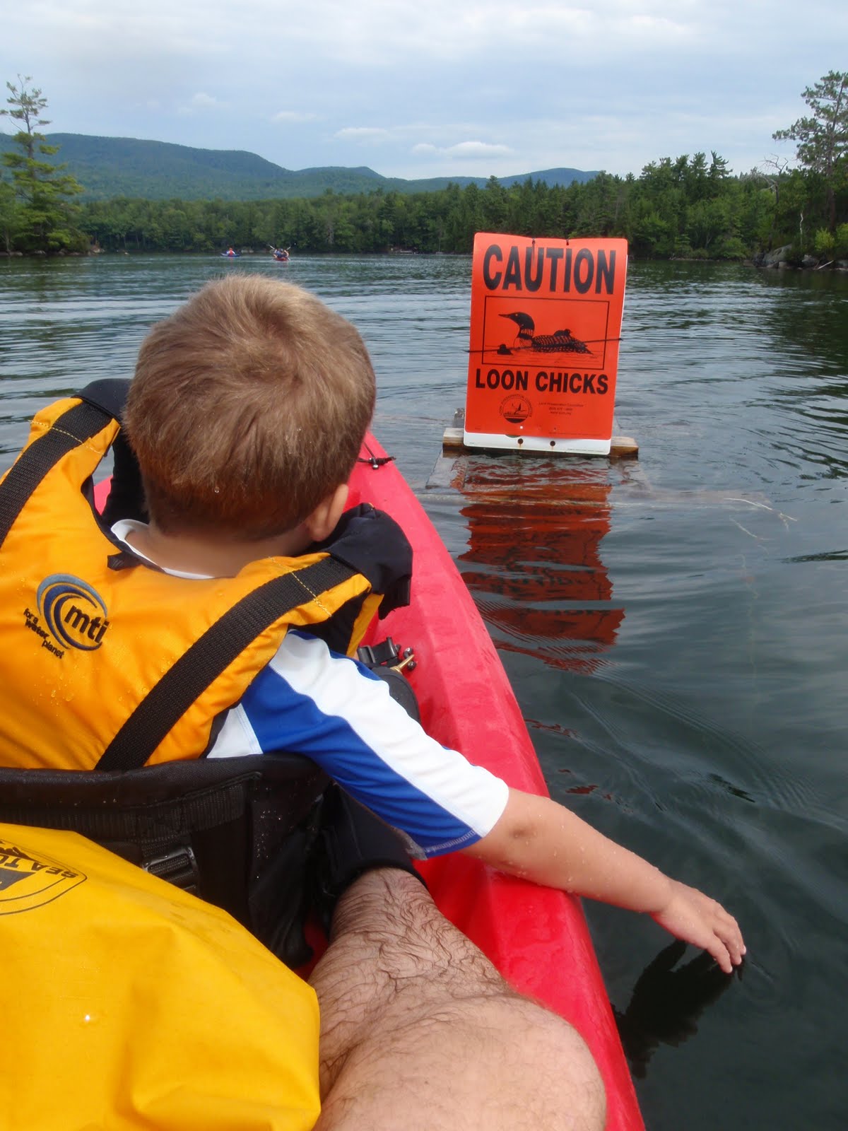
Toward the end of our trip, we passed a sign that gave me some hope we might see a loon.  

Sure enough, this majestic loon came paddling right by two of the kayaks in our group and kept diving below the surface. He didn't stay on the surface for very long, so I kept my camera pointed toward where I thought he might pop up in hopes of capturing a good picture.  He kept popping up in drastically different locations from what I expected though.

Here's the loon in between dives.  I was surprised how big he was.  I always thought they were probably about the same size as a duck.  You don't get the sense of it from this picture, but he seemed about twice as big as a mallard duck - more like the size of a goose or a swan.


Many thanks and kudos to Kristen from the Lakes Region Conservation Trust for organizing and leading us on this wonderful day on the water!  I am so glad the boys agreed to go with me on this trip.  After we got out of the water and were loading up the car, the boys made my day when, without prompting, they both told me that the had fun.

Stats for the paddle log:  (Note: The stats on Garmin Connect are inaccurate because I forgot to click "stop" on my Forerunner.  The Garmin Connect data includes the first stretch of road we drove in the car until my Forerunner beeped at me to tell me we had finished another mile.  Doh!  Quick!  Turn it off!)
  • Date: 21 August 2010
  • Time In: 8:39 a.m.
  • Time Out: 12:17 p.m.
  • Elapsed:  3 hours 38 minutes
  • Moving Time (GPS):  3 hrs 5 minutes 
  • Stopped Time (GPS):  33 minutes
  • Mileage: 5.1 miles by GPS
  • Sea State: 0
  • Winds: Negligible
  • Air Temp:  50F warming up to 75F
  • Water Temp: 75.8F digital
  • Current:  None.
  • Gauge Height:  Lake level is about a foot or two below normal.
  • Avg Speed (GPS):  1.7 mph
  • Max Speed by (GPS):  4.1 mph
  • Rapids?  None. 
  • Hazards?  None.
  • Kit: Ocean Kayak Malibu Two XL. Flop hat, NRS paddling gloves, short sleeve shirt, swim trunks, Keen sandals.  Because it was initially so cold in the morning, I brought my Kokotat jacket & NRS pants, and I brought the boys' rain pants and windbreakers, but we didn't end up needing them.
  • Configuration: 6 year old YB rode in the front seat and I rode in the middle seat of our Ocean Kayak Malibu Two XL.  9 year old ES rode in his own Perception Acadia Scout.
  • Route:  Put-in from a public access point along a private road in the northwest end of Squam Lake.  [Note: If you are reading this in Google Reader, then you will not see the Garmin Connect map here for some reason.  You actually have to come to my blog to see the map of where we went from the GPS.]   

  • Other comments (such as wildlife spotted): Mergansers, loon, frog, toad, diving birds (terns?).
Similar to when we finished our West Rattlesnake Mountain hike, we got in the car and I did a search in our car navigation system for the nearest restaurant.  Again, Walter's Basin in Holderness was still the closest.  However, Holderness wasn't exactly on the way back to home, so we started driving back toward Moultonborough and searching for something else.

We ended up stopping at the Corner House Inn in Sandwich, NH.  It seemed kinda fancy for us in swim trunks and t-shirts, but they had a pub upstairs and said we were welcome to have lunch there.  Lunch was AWESOME.  I just like saying, "I had an awesome sandwich in Sandwich."