
I was aware of the steepness of a hike being a significant factor in a hike's difficulty. Hiking books and websites like the Washington Trails Association consider anything over 1,000 feet per mile a "difficult" uphill slope. Because of that, I have been keeping a Hiking Log spreadsheet that tracks the mileage, elevation gain, and slope (in feet per mile) of each hike I've done. I use it to evaluate new places I want to hike by comparing it to previous hikes I've done, both with and without kids in tow.
I've done two hikes in the past that crossed that 1,000 feet per mile threshold of difficulty, both in Hawaii about two years ago - Koko Head and Olomana. The longest hike I've done was the Elk Mountain hike last summer at 7.2 miles, and I've been wanting to try more, longer hikes like that.
So reading the description of the Mailbox Peak hike, I figured 6 miles and > 1,000 feet per mile would be a good test of my endurance - not quite as long as my longest hike, but balanced out with the steeper slope.
Yeah, that wasn't very smart of me.
Aside: Have you ever heard that comedian Bill Engvall? He does a routine called "Here's Your Sign," where he describes how stupid people should be required to wear signs.
Engvall's "Here's Your Sign" routine is pretty darn funny, but after yesterday's climb, I have to say I should be wearing one of those signs.
Here are a couple of facts I neglected to mentally digest before embarking on this
1) While I was able to do two previous hikes > 1,000 feet per mile, they were 1.6 and 3.2 miles long. This was twice as long.
2) The WTA description warns that the first part is flat, so when you take into account the length of the hike that is actually climbing in elevation, it's really over 1,500 feet per mile.
If I plot the Koko Head and Olomana profiles on top of the profile from the Mailbox Peak climb, you can see that Mailbox Peak puts the previous two to shame:

Of note, at the Mailbox Peak trailhead, you will find this warning sign...

Ahem.
For those of you considering going on this adventure, here's a closeup of the trail map:


This genuine smile provided at the beginning of the trail.


The WTA description about this being a trail of heartbreak could use a little more elaboration. You see, after you've climbed... and climbed... and climbed... and you're exhausted and out of breath, and you THINK you've reached the top...


When you come out onto a ledge overlooking I-90 below and you see this view looking up, THAT is the last stretch to the top. Rob is in much better shape than me, and he pushed on ahead to the top. I followed him up slowly. The top was actually in the clouds up there.

Wait... what is that?
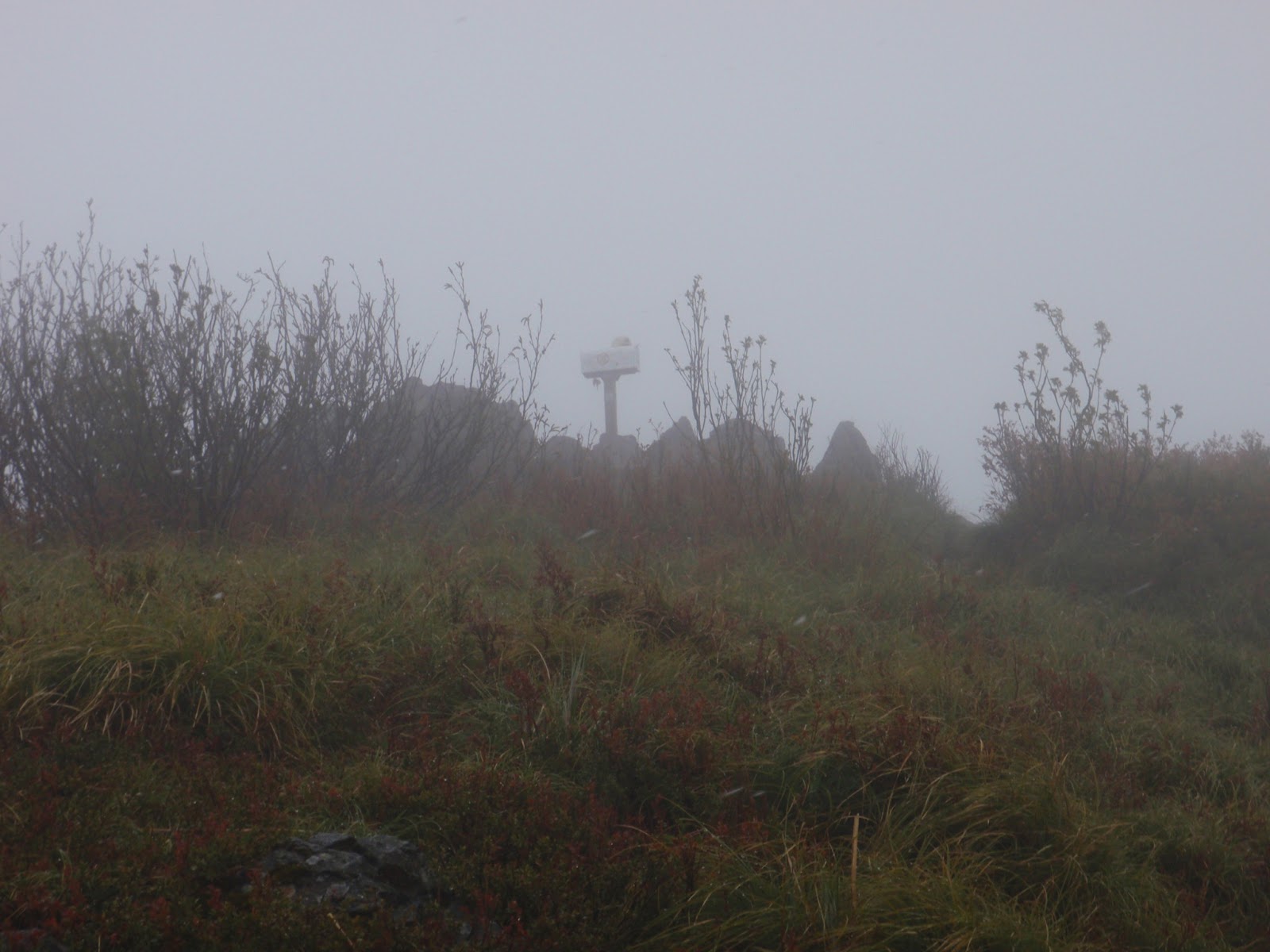
Could it be?

I MADE IT!
It took me just shy of 4 hours to reach the top. I suspect the view would be stellar if the peak weren't buried in clouds. What the picture above doesn't show is that it was 39 degrees, winds blowing about 15 knots, and snowing sideways. My hands were so numb from the cold, I couldn't feel the camera buttons. I'm surprised I got this picture. Rob was originally going to make a pot of coffee here at the top, but it was too cold, windy, and snowing, so we headed back down to the overlook above I-90.


There's Rob down there making his coffee.


It was pretty tough going back down. I was glad to have two hiking sticks with me. Several times one of my feet slipped out from under me, but I was able to catch myself with my hiking sticks. My legs felt like jello when I got to the bottom, and they're pretty darn sore today.
In the end, I'm glad I did it. I learned an important lesson in self-assessing my own abilities and evaluating the difficulty a potential future hike. I'm thankful for a few answered prayers I said on the way up for the strength, energy, and endurance to make it to the top, and for a few answered prayers I said on the way down that I made it without slipping and without my legs giving out on me from exhaustion. I'm also thankful for my friend Rob inviting me to go with him and for being gracious in waiting for slow-poke me to catch up with him along the way.
Trip Stats:
Summary:
- Date: 30 May 2013
- Time of Departure: Left Bremerton at 8:15 a.m. and drove around via the Tacoma Narrows Bridge, made one pit-stop along the way and arrived at the trailhead at 10 a.m. We geared up and headed out on the trail at 10:13.
- Reached the Peak: 2:03 p.m.
- Time of Return: We stopped at the overlook to eat lunch before heading back down. We departed the overlook at 2:44 p.m. and arrived back at the car at 5:07 p.m.
- Elapsed: 6 hours 54 minutes
- Moving Time (GPS): 3 hours 51 minutes
- Stopped Time (GPS): 3 hour 3 minutes
- Mileage (GPS): 6.14 miles
- Avg Speed (GPS): 1.6 mph
- Elevation Gain: 4,722 feet
- Max Elevation: 4,841 feet
- Weather: Mostly cloudy, intermittent light showers, snowing at the peak.
- Winds: Calm in the trees, approx 15 knots at the peak.
- Air Temp: 55F at the trailhead, dropping down to 39F at the peak.
- Trail: Well-defined hard-pack dirt or gravel trail, lots of tree roots.
- Crowds? Not crowded, but not alone. There were about four cars parked at the trail head. On our way up, we passed about 4 people headed down. On our way down, we passed about 10 people headed up.
- Hazards? Some steep
dropoffs. No sources of water.
- Kit: Long sleeve T-shirt, cargo pants, L.L. Bean rain jacket, Merrell Moab Gortex hiking boots, ballcap, two walking sticks.
- Facilities: There was a privy near the trailhead. There are no sources of water along this trail.
- Wildlife: Didn't see any.


No comments:
Post a Comment