Showing posts with label National Parks. Show all posts
Showing posts with label National Parks. Show all posts
Wednesday, December 4, 2013
DC Gouge: Antietam Luminaries
Hey folks,
Once a year in December, the National Park Service puts luminaries out across the Antietam National Battlefield - one luminary for each of the 23,000 soldiers killed at the battle. You stay in your car and just drive the tour route through the battlefield. It's happening this Saturday, 7 December. You can find out more information at the National Park Service website: http://www.nps.gov/anti/planyourvisit/luminary.htm
Tuesday, June 18, 2013
Grand Teton National Park
Yes, yes, I'm alive.
'Tis PCS season once again. We have yet to make a same-coast PCS trip. All of our PCS moves have been at least 3,000 miles across country or across the ocean. The Navy has sent us back to the Pentagon again, and we're excited to enjoy all there is to see and do around the National Capital Region. The timing worked out well for us this time to let the boys finish school and then drive across country.
I enjoy making the drive across country and seeing America along the way. I was disappointed to miss the drive across country from DC out to Bremerton in 2011. My Lovely Wife had to do that road trip with the boys and a good friend from church who rode with her. I would have liked to have more time to drive across country this time and see and do more like our previous trips (see my blog posts from our road trip in September to October 2008), but I had to get to my new job by a certain date.
Since we had been to Yellowstone National Park a couple of times on previous drives across country, we decided to veer a little south this time and see something new and different -
A few things I learned in the process of planning our visit and going to the Tetons:
- "Jackson Hole" is a term used for the valley to the east of the Tetons, to include the town of Jackson, Wyoming.
- Most of the rest of Wyoming does not consider Jackson Hole to be part of Wyoming. There's a vast tourist business flowing through Jackson Hole year-round. In the winter, people go for the skiing and winter sports. In the summer, people go for the hiking, biking, kayaking, canoing, rafting, and just about any other outdoor activity you can imagine.
- EVERYTHING is expen$ive in Jackson Hole. The statistics of the number of tourists who go there are mind-boggling, and all the hotels and restaurants enjoy charging high prices just because they can. I suffered some sticker-shock and pain in my wallet as soon as I started investigating hotels in Jackson Hole.
So, to help conserve our finances but still have two days of activities in GTNP, we drove to Rexburg, Idaho and spent the night there. Rexburg is just 2 hours west of Jackson, and you can actually see the back side of the Tetons from there. By doing that, we got up, drove into the park, had most of a day there, $pent just ONE night in a Jack$on Hole hotel, got up had most of a second day there, then continued driving east and stayed the night in a cheaper hotel in Casper, WY.
Day 1:

I figured with it being a big tourist trap that gas would be pretty expensive in Jackson Hole, so we stopped and topped off the gas tank in Idaho on our way inbound. Much to my surprise, it turns out that was actually a mistake. Gas was significantly cheaper in Jackson Hole than it was back in Idaho. Go figure.
I found this website useful - it provided four recommended day hikes in GTNP with kids. Because I liked what he had to say on his website, I ordered his book, too, and I was glad I did. I wish I had more time to do all of the hikes he recommended, but decided in the short time available to do the hike he wrote was his kids' favorite - Hidden Falls and Inspiration Point.
There are a TON of places to eat in Jackson Hole. I should have done more research before we got there on where we wanted to eat. They're all local unique places, no national chains. I made the mistake of just walking in someplace for lunch that I thought looked good. The food was okay, but the service was downright terrible. If I would have looked at the Yelp reviews on my phone before we walked in there, I would have stopped and walked out. I was kind of pissed off we wasted a meal there when there were so many other places with great reviews.
After lunch, we headed to the Jenny Lake Visitor Center. We parked there and caught the Water Taxi across Jenny Lake.

The water taxi is open to the fresh air, but there's a canopy for shade over the forward half of the seats. It carries about 30 people or so. It's first come first serve and runs about every 15 minutes. Their cashiers are pretty quick and efficient, and they DO take credit cards.

From the landing on the other side of Jenny Lake, we went on a short day hike to Hidden Falls (0.5 miles) and Inspiration Point (another 0.5 miles past Hidden Falls).
 The trail is very well-defined and mostly fenced-in with wood post fences like in the picture above, so it'd be kind of hard to get lost here.
 There was an incredible volume of water gushing down this valley into Jenny Lake. When you look at this picture, you need to imagine the deafening ROAR of rushing water. Here, let's see if this video will help...

The Hidden Falls were gorgeous and totally worth the trip. Of note, we almost missed them. You see, they're sort of... well... Hidden. If you follow the sound of the water and go the direction you think you need to go across the bridges, then you'll only get a partial view of the falls through a bunch of trees off on the right. Thankfully, I overheard someone telling someone else on the trail to go back across the bridges (away from the river and the sound of the water) and turn right up what looks like the smaller / less traveled trail. That path takes you to the much better viewing point that you see in the picture above.

The trail to Hidden Falls was pretty flat. From there, there's a slight climb half a mile up to get to Inspiration Point. Now, you might think that a 1 mile hike (2 miles round trip) is really short and pretty darn easy, but if you're not used to the altitude (~6,700 feet) then you're going to be winded.

 There was a pretty nice view from Inspiration Point. I was glad we did it.

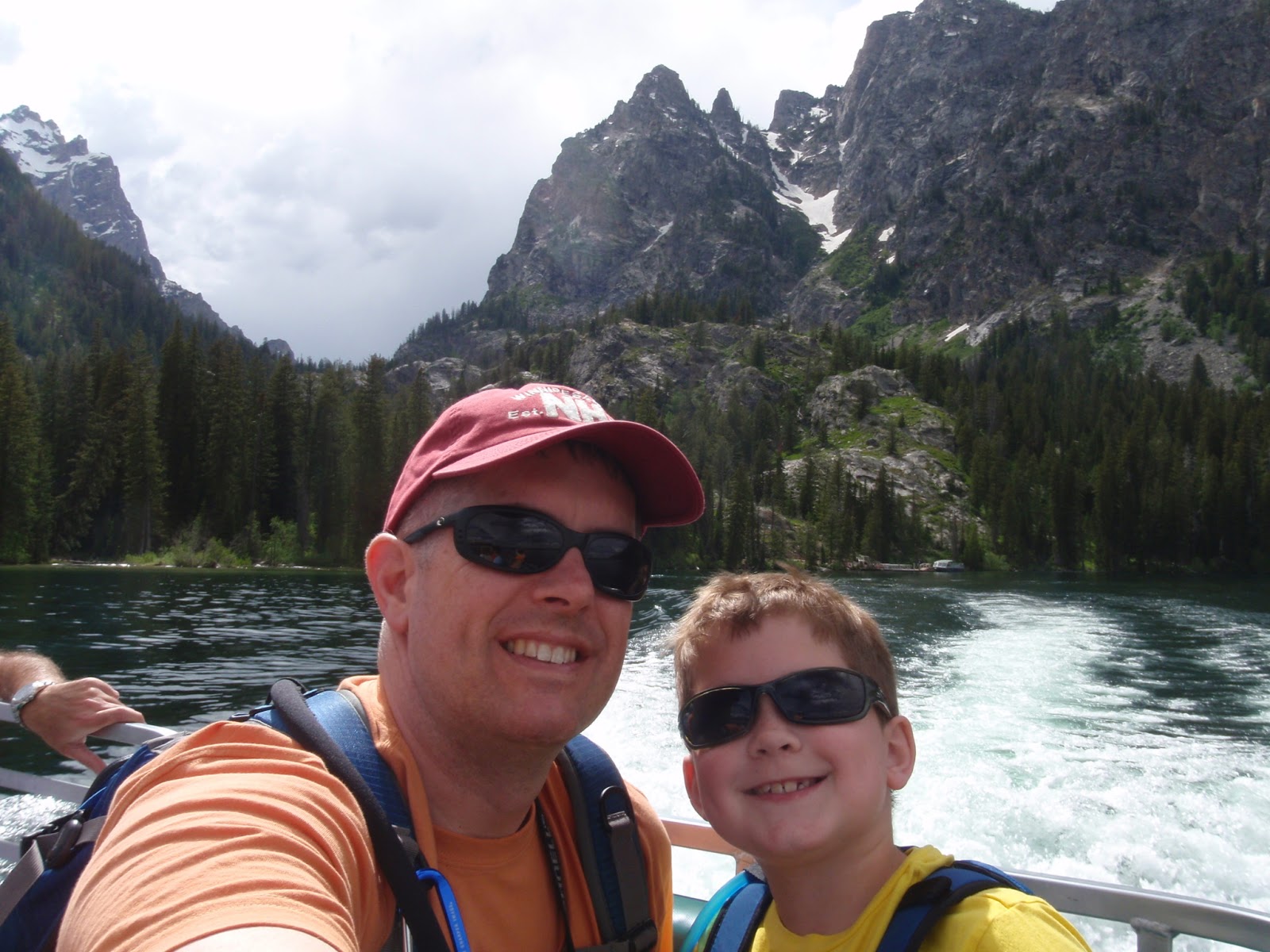
 Me and YB on the water taxi back to the Jenny Lake Visitor Center
 To get a feel for the volume and variety of visitors they get here: The water taxi operators clear this board every day. They ask their visitors to put the magnet for their state up on the board or write the name of their country on the right, and they fill the board almost every day.
The Tram
Next, we drove down to the Teton Village and took the aerial tram ride up to the top of the mountain. There are no reservations for the tram ride - it's first come, first serve. They sell tickets for the tram online, and when you buy the tickets they're good for a one week period. I DO recommend buying them online because they are cheaper online (save $6 per ticket) and easier to pickup at the will-call window.
 While waiting for the tram, the boys pretended to be terrified of the ride to come.
 We were there for the second to last tram up for the day and it was pretty empty. We almost got the entire tram to ourselves.
 It was a really cool 12 minute ride up to the top. We saw three moose below us on our way up. Once we got up to the top, though, oh my! It was COLD and HOWLING wind. The view was spectacular, but we turned around and got on the next tram back down because we were freezing.

For dinner, I had learned my lesson and checked Yelp before picking a place to eat. We had dinner at the Sweetwater restaurant (Yelp listing), and it was EXTRAORDINARILY FABULOUS. I can't tell you enough how awesome both the food and the service were at Sweetwater. It was so good, I might just be willing to pay for the plane ticket to go back to Jackson Hole and eat there again.
We stayed at the Lexington Hotel, which was a VERY nice hotel with an excellent continental breakfast, but it cost twice as much as any other hotel on our trip across country.
Day 2:
 The next day, we checked out of the hotel and headed back to the Jenny Lake Visitor's Center again - this time to rendezvous in the parking lot with Solitude Float Trips for a 10-mile scenic float trip down the Snake River.
 Our guide, Bernie, and his team from Solitude Float Trips did a great job. It was a very well-organized and efficient operation. They met us in the Jenny Lake Visitor's Center Parking lot where we all piled into their vans towing the boats on these flatbed trailers. They drove us up to Deadman's Bar and put us in the water there.
 After putting the boat in the water, the used the flatbed trailer as a sort of dock / loading platform, so we were all completely dry when we sat down in the boat. In fact, the rest of the ride was very smooth and we wouldn't have gotten wet at all if it hadn't been for certain members of my family sticking their hands in the water and flicking it at each other.


Bernie was great with our boys, talking to them, asking them questions, and he let each of them take a turn at guiding the boat.
 The scenery was spectacular, and we saw three bald eagles, an osprey, and a prong-horn along the way. I was also thankful to Bernie for giving us his local perspective on the area since he lives there year-round. He told us the best place to eat in the national park was at the Signal Peak Lodge. Someone else we had met along the way had recommended going to see Signal Peak because you can drive right to the top and enjoy the view. So Bernie's claim of the food being good at the lodge sealed the deal. After we got off the river, we headed up to the Signal Mountain Lodge.

The Signal Mountain Lodge is on the eastern shore of Lake Jackson, looking westward across the lake toward the Tetons. Bernie was right - the food was fantastic. The service was okay - not bad / but not extraordinary. After lunch, we drove up to the top of Signal Peak.
 Now, before you go driving up there, you should know that the viewpoint at the top has a pretty amazing panoramic view of the valley from north to east to south, but the view to the west (toward the Tetons) is blocked by trees. I went up there expecting to see another great view of the Tetons and was a little surprised and slightly disappointed, so I just wanted to help you manage expectations if you go driving up there, too.
By that time it was early afternoon and we needed to hit the road. We drove about 5 hours east / southeast from there to where we spent the night in Casper, Wyoming. Overall, I'm pretty pleased with how our plan ended up enabling us to get two days' worth of activities in GTNP without paying for two night's hotel stay there. There was SO much to do there! I would LOVE to go back someday and spend a week hiking, biking, kayaking, and just soaking in the splendor of the natural beauty of the park.
...I just might have to take out a home equity loan to afford it.
'Tis PCS season once again. We have yet to make a same-coast PCS trip. All of our PCS moves have been at least 3,000 miles across country or across the ocean. The Navy has sent us back to the Pentagon again, and we're excited to enjoy all there is to see and do around the National Capital Region. The timing worked out well for us this time to let the boys finish school and then drive across country.
I enjoy making the drive across country and seeing America along the way. I was disappointed to miss the drive across country from DC out to Bremerton in 2011. My Lovely Wife had to do that road trip with the boys and a good friend from church who rode with her. I would have liked to have more time to drive across country this time and see and do more like our previous trips (see my blog posts from our road trip in September to October 2008), but I had to get to my new job by a certain date.
Since we had been to Yellowstone National Park a couple of times on previous drives across country, we decided to veer a little south this time and see something new and different -
A few things I learned in the process of planning our visit and going to the Tetons:
- "Jackson Hole" is a term used for the valley to the east of the Tetons, to include the town of Jackson, Wyoming.
- Most of the rest of Wyoming does not consider Jackson Hole to be part of Wyoming. There's a vast tourist business flowing through Jackson Hole year-round. In the winter, people go for the skiing and winter sports. In the summer, people go for the hiking, biking, kayaking, canoing, rafting, and just about any other outdoor activity you can imagine.
- EVERYTHING is expen$ive in Jackson Hole. The statistics of the number of tourists who go there are mind-boggling, and all the hotels and restaurants enjoy charging high prices just because they can. I suffered some sticker-shock and pain in my wallet as soon as I started investigating hotels in Jackson Hole.
So, to help conserve our finances but still have two days of activities in GTNP, we drove to Rexburg, Idaho and spent the night there. Rexburg is just 2 hours west of Jackson, and you can actually see the back side of the Tetons from there. By doing that, we got up, drove into the park, had most of a day there, $pent just ONE night in a Jack$on Hole hotel, got up had most of a second day there, then continued driving east and stayed the night in a cheaper hotel in Casper, WY.
Day 1:

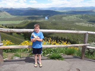
View of the Tetons from near Rexburg, Idaho
I figured with it being a big tourist trap that gas would be pretty expensive in Jackson Hole, so we stopped and topped off the gas tank in Idaho on our way inbound. Much to my surprise, it turns out that was actually a mistake. Gas was significantly cheaper in Jackson Hole than it was back in Idaho. Go figure.
I found this website useful - it provided four recommended day hikes in GTNP with kids. Because I liked what he had to say on his website, I ordered his book, too, and I was glad I did. I wish I had more time to do all of the hikes he recommended, but decided in the short time available to do the hike he wrote was his kids' favorite - Hidden Falls and Inspiration Point.
There are a TON of places to eat in Jackson Hole. I should have done more research before we got there on where we wanted to eat. They're all local unique places, no national chains. I made the mistake of just walking in someplace for lunch that I thought looked good. The food was okay, but the service was downright terrible. If I would have looked at the Yelp reviews on my phone before we walked in there, I would have stopped and walked out. I was kind of pissed off we wasted a meal there when there were so many other places with great reviews.
After lunch, we headed to the Jenny Lake Visitor Center. We parked there and caught the Water Taxi across Jenny Lake.

Waiting to Board the Jenny Lake Water Taxi
The water taxi is open to the fresh air, but there's a canopy for shade over the forward half of the seats. It carries about 30 people or so. It's first come first serve and runs about every 15 minutes. Their cashiers are pretty quick and efficient, and they DO take credit cards.

On the Jenny Lake Water Taxi
From the landing on the other side of Jenny Lake, we went on a short day hike to Hidden Falls (0.5 miles) and Inspiration Point (another 0.5 miles past Hidden Falls).


Hidden Falls
The Hidden Falls were gorgeous and totally worth the trip. Of note, we almost missed them. You see, they're sort of... well... Hidden. If you follow the sound of the water and go the direction you think you need to go across the bridges, then you'll only get a partial view of the falls through a bunch of trees off on the right. Thankfully, I overheard someone telling someone else on the trail to go back across the bridges (away from the river and the sound of the water) and turn right up what looks like the smaller / less traveled trail. That path takes you to the much better viewing point that you see in the picture above.

The Trail to Inspiration Point
The trail to Hidden Falls was pretty flat. From there, there's a slight climb half a mile up to get to Inspiration Point. Now, you might think that a 1 mile hike (2 miles round trip) is really short and pretty darn easy, but if you're not used to the altitude (~6,700 feet) then you're going to be winded.


YB on the trail back to the water taxi

The Tram
Next, we drove down to the Teton Village and took the aerial tram ride up to the top of the mountain. There are no reservations for the tram ride - it's first come, first serve. They sell tickets for the tram online, and when you buy the tickets they're good for a one week period. I DO recommend buying them online because they are cheaper online (save $6 per ticket) and easier to pickup at the will-call window.


We spotted 2 more moose on our way to dinner.
For dinner, I had learned my lesson and checked Yelp before picking a place to eat. We had dinner at the Sweetwater restaurant (Yelp listing), and it was EXTRAORDINARILY FABULOUS. I can't tell you enough how awesome both the food and the service were at Sweetwater. It was so good, I might just be willing to pay for the plane ticket to go back to Jackson Hole and eat there again.
We stayed at the Lexington Hotel, which was a VERY nice hotel with an excellent continental breakfast, but it cost twice as much as any other hotel on our trip across country.
Day 2:


Bernie was great with our boys, talking to them, asking them questions, and he let each of them take a turn at guiding the boat.


Lunchtime View
The Signal Mountain Lodge is on the eastern shore of Lake Jackson, looking westward across the lake toward the Tetons. Bernie was right - the food was fantastic. The service was okay - not bad / but not extraordinary. After lunch, we drove up to the top of Signal Peak.

By that time it was early afternoon and we needed to hit the road. We drove about 5 hours east / southeast from there to where we spent the night in Casper, Wyoming. Overall, I'm pretty pleased with how our plan ended up enabling us to get two days' worth of activities in GTNP without paying for two night's hotel stay there. There was SO much to do there! I would LOVE to go back someday and spend a week hiking, biking, kayaking, and just soaking in the splendor of the natural beauty of the park.
...I just might have to take out a home equity loan to afford it.
Sunday, October 7, 2012
Olympic National Park - Dosewallips River
This was supposed to be hike #3 in the Falcon Guide titled Best Easy Day Hikes - Olympic National Park. Unbeknownst to me, at some point between when the book was published in 2008 and now, the road was washed out about 5 miles short of the entrance to the National Park.
 At the point where the road is washed out, we found about a dozen cars parked (see the victory pose photo below), so we figured people were just beginning their hikes from that point onward. We encountered a few hikers coming out and asked what it was like. They told us after the initial switchback trail up over the hill above the washout that it was pretty flat and easy.

 The trail over the hill was well-defined hard pack dirt and easy to follow. When we got over the hill, the trail dropped us back down onto Dosewallips Road on the other side of the washout.

From the point we rejoined the Dosewallips Road to the Elkhorn campsite, we enjoyed the deafening roar of the river at our side. Still photos don't capture the essence of walking along the roaring river, so I had to post a short video clip instead. The section of road from the washout to the Elkhorn campground was a nice flat road and would have been nice for a bike ride. We saw a family riding their bicycles near the campground. You'd just have to push your bikes up over that first hill.
 The Elkhorn campground was a nice place and clearly still gets used. There was no privy or any sort of facilities available though. We spent some time by the river skipping rocks and marveling at how crystal clear the water was. Considering how little rain we've had in the last couple of months, it was odd to see so much water in the river, but it was frigidly cold glacier runoff.
 From this sign by the Elkhorn campground onward, the road starts a steady uphill climb and diverges away from the river. If you look at the altitude profile in my Garmin track below, you'll see that the trail was fairly flat - about 100 feet of elevation gain over the first 1.4 miles, then it gained a little over 300 feet in the next 0.6 miles as we climbed up the road away from the Eklhorn campground. There really wasn't much to see here. When we got 2 miles away from where we parked the car, we decided to head back down again.
 There were lots of these little white and black butterflies flittering about all around us along the trail.
 We also spotted a couple of different catepillars, lots of pearly everlasting and some other common flowers along the way.


This was a first. When we arrived back at the car, the boys declared "victory pose!" and ordered me to take a photo of them. Goofballs.
Hike Stats: When I'm searching for places to hike with my kids, I appreciate having some basic facts and figures about the hike for me to judge if it's doable with my kids. With that in mind, I hope other parents considering this hike find the following information useful.


This is what the switchback part of the trail looked like.


Blunoz Self Portrait by the Dosewallips River


Long shadows at the end of the day.

On the hill over the washout.

Victory Pose
This was a first. When we arrived back at the car, the boys declared "victory pose!" and ordered me to take a photo of them. Goofballs.
Hike Stats: When I'm searching for places to hike with my kids, I appreciate having some basic facts and figures about the hike for me to judge if it's doable with my kids. With that in mind, I hope other parents considering this hike find the following information useful.
- Date: 6 October 2012
- Time of Departure: Left the house about 10 a.m. Stopped at the Quilcene Ranger Station to stamp my book, then had lunch at Logger's Landing (great food and excellent service). By the time we got up to the end of the Dosewallips Road and started our hike, it was 1:41 p.m.
- Time of Return: Around 4:30 p.m back at the car. Held up by the Hood Canal Bridge opening on our way back. Stopped and picked up Mike's Four Star Barbecue in Port Gamble on our way home. Got home around 6:30 p.m.
- Elapsed: 2 hours 52 minutes
- Moving Time (GPS): 1 hours 48 minutes
- Stopped Time (GPS): 1 hour 4 minutes
- Mileage (GPS): 5.0 miles
- Avg Speed (GPS): 1.8 mph
- Elevation Gain: 725 feet
- Max Elevation: 1,004 feet
- Weather: Clear and sunny.
- Winds: None.
- Air Temp: 61F climbing to 66F by the car thermometer. It felt a little chilly at spots along the river.
- Trail: Well-defined hard-pack dirt or gravel trail.
- Crowds? Not crowded, but not alone. There were about a dozen cars parked at the washout. We passed about a dozen people along the way going in both directions.
- Hazards? Some short but steep
dropoffs into roaring rapids below.
- Geocaches? Didn't bother looking - assumed there were none because it's a National Park.
- Kit: Long sleeve T-shirt, shorts, new Merrell Moab Gortex hiking boots, ballcap, walking stick.
- Route: Intended to follow the route of #3 in my ONP day hikes book, but never made it to the Dosewallips Park Ranger station due to the road washout. Note to self: Check road conditions on national park website. Instead just hiked along the road. If I didn't have my kids with me, I would have kept going all the way up to the Park Ranger Station.
- Facilities: None.
Saturday, September 29, 2012
Weekend Getaway - Astoria, Oregon
For Labor Day weekend, we looked a little bit farther out of our normal range of outside activities to find a place to spend the weekend. My wife and I both loved the movie Goonies when we were kids, and we decided to go down and check out Astoria, Oregon.

Before we went there, I kept calling it "Uh-story-uh." After spending the weekend there, I have learned everyone down there calls it "Ass-story-uh." It's a pretty little seaside town right at the mouth of the Columbia River. It's only about 3 1/2 hours drive from Bremerton, so it makes for a nice not-too-far weekend getaway.

We stayed at the Holiday Inn Express right under the Astoria bridge. It was a pretty nice place - and the prices reflected it, but we got some sort of weekend getaway discount deal. They serve a pretty decent continental breakfast in the lobby, too.
It turns out there are several movies that have been filmed in Astoria, not just Goonies. Some of the others we recognized were Kindergarten Cop and Short Circuit. If you stop at the Chamber of Commerce, for $1 you can have a paper map and an audio CD that takes you through a tour of the town and past all the movie locations. We went by the Goonies' house, the winding road where Mikey's older brother chased them on the little girl's bike, the window where Chunk smashes his milkshake while watching the police chase, the museum where Mikey's father worked and was taking down the flag at the beginning of the movie, and the jail.
 They have turned the jailhouse into a film museum and will let kids film their own movie inside. Out in front of the jail they have the black Jeep Cherokee the Fratelli family used in the movie, complete with bullet holes in the back, and the cast of the movie all autographed the dashboard with a black permanent marker.
 Driving that winding road that Mikey's brother rode the little girl's bike on takes you up to the top of the hill overlooking Astoria and the Astoria Column. The view here is truly spectacular and made it worth the drive down from Bremerton. Heck, even if you didn't want to pay for a hotel to stay overnight, you could make this a day trip - drive down, go to the top of the tower, see the Goonies locations, and drive back in one day. This picture is looking south from the top of the Column toward the Lewis & Clark River. The picture at the top of this post is the view toward the Columbia River and the bridge from the top of the column.
 They sell balsa wood gliders in the gift shop at the bottom of the column. They will hand you a Sharpie marker to write your name on the glider before you throw it off the top of the column. Granted, first you have to climb the 100+ spiral staircase steps to the top, but it was totally worth it.
 The boys conducting pre-flight checks on their gliders. We had a blast watching our gliders soaring off into the distance.
 We had lunch at this boat-turned-fish'n'chips-grill called the Bowpicker. DANG it was good stuff. They make fish'n'chips using fresh tuna, and it was absolutely extraordinary! Small boats aside, there were a plethora of awesome local restaurants in Astoria serving excellent dishes using fresh local produce. There are a couple of breweries, too, but I wasn't overly thrilled with their beer. We went to two breweries and they both served the typical Pacific Northwest style of IPA with heavy hops. I'm much more a fan of New England style lagers. Oh, but the Crater Lake root beer they had on tap at the Wet Dog Cafe was delicious!
 There's a maritime museum on the waterfront in Astoria - the Columbia River Maritime Museum. I've been to a lot of small-town museums before, and 99% of them have been boring and lame - some collection of random odds and ends and local history with the name "museum" slapped on the building to try and create a tourist attraction. Not so in this case.
 This museum was actually very well done with high quality exhibits about the Graveyard of the Pacific, the local US Coast Guard rescue boats, the Columbia River pilots, the salmon fishing industry, and a wing of Navy stuff from the battleship USS OREGON and the two WWII cruisers to carry the name USS ASTORIA. The boys loved playing in the tug boat pilot house.
 We also visited Fort Clatsop National Historic Park. After Lewis & Clark reached the Pacific coast, this is where they spent the winter before heading back east. This is a replica of the fort that was built using the drawings from Lewis & Clark's journals.
 We got there just in time for a hike led by a Park Ranger, and I continue to enjoy every chance I can get to learn from them. Park Rangers always lead awesome tours and have so much fascinating history to teach and explain.

 There's a nice trolley that goes back and forth along the waterfront in Astoria, too. It only costs a dollar to ride, and we totally got our money's worth. I would go back and ride the trolley again more for the things I learned from the conductors than for the transportation they provided.
 The conductors were full of historic trivia and stories about the area. Other people on the trolley commented on how each of the conductors had different stories to tell and they learned something new and different each time they rode.
Overall it was a wonderful trip. If you're looking for a weekend getaway from Bremerton, or even just a day-trip, I highly recommend checking out the view from the Astoria Column, taking a ride on the trolley, visiting the maritime museum, and doing the Chamber of Commerce's driving tour of the movie sights.

Before we went there, I kept calling it "Uh-story-uh." After spending the weekend there, I have learned everyone down there calls it "Ass-story-uh." It's a pretty little seaside town right at the mouth of the Columbia River. It's only about 3 1/2 hours drive from Bremerton, so it makes for a nice not-too-far weekend getaway.

View from Holiday Inn Express
We stayed at the Holiday Inn Express right under the Astoria bridge. It was a pretty nice place - and the prices reflected it, but we got some sort of weekend getaway discount deal. They serve a pretty decent continental breakfast in the lobby, too.
It turns out there are several movies that have been filmed in Astoria, not just Goonies. Some of the others we recognized were Kindergarten Cop and Short Circuit. If you stop at the Chamber of Commerce, for $1 you can have a paper map and an audio CD that takes you through a tour of the town and past all the movie locations. We went by the Goonies' house, the winding road where Mikey's older brother chased them on the little girl's bike, the window where Chunk smashes his milkshake while watching the police chase, the museum where Mikey's father worked and was taking down the flag at the beginning of the movie, and the jail.


The boys with Sacagawea.
One of the stories I learned from the Park Ranger was how Lewis & Clark referred to her simply as "the squaw" until one day a canoe full of their precious journals and scientific instruments capsized, and she dove in and saved the stuff. It wasn't until she saved their gear that they bothered to learn her name and refer to her by her name in their journals.

Overall it was a wonderful trip. If you're looking for a weekend getaway from Bremerton, or even just a day-trip, I highly recommend checking out the view from the Astoria Column, taking a ride on the trolley, visiting the maritime museum, and doing the Chamber of Commerce's driving tour of the movie sights.
Sunday, September 23, 2012
Olympic National Park - Crescent Lake
For my birthday, I asked my family to go with me for a short hike and a bike ride up at Crescent Lake in Olympic National Park about a half hour drive west of Port Angeles. The two destinations I had in mind were #14 and #15 in the Falcon Guide titled Best Easy Day Hikes - Olympic National Park.
On our way up there, we stopped at Fat Smitty's for lunch. One of my shipmates told me they had the best burgers on the peninsula. If you're headed from Kitsap over toward anywhere on the Olympic Peninsula, you can't miss it.
 Right on Highway 101 there's this little shack of a restaurant with a huge chainsaw-art carving of a ginormous double-decker hamburger with all sorts of fixings on it. I thought this squat-totem-pole of burger-worship was just an exaggeration to gather people's attention...

Their signature item, the Fat Smitty burger really is that big. The waiter recommended it if we hadn't been there before, but didn't offer any explanation of how big it was. The menu also offered no description to warn us of the ginormous greasy monstrosity we would be receiving off the grill.
When the waiter set them down in front of us, my eyes nearly popped out of their sockets, and it took a few moments to get over the shock. The waiter said the record is 45 seconds to eat an entire Fat Smitty burger. He recommended putting all your weight into squashing it down with your palm on top of the burger, then picking it up and not putting it down again until you were all done. I'm sorry to disappoint you, but there was no way I could finish it.
After lunch, we followed Highway 101 along the southern edge of the lake to Lake Crescent Lodge. Just before the lodge is a boat ramp and a parking area for the Marymere Falls trailhead. This was a short hike (1.5 miles round trip) and pretty easy for families with children. Because of that, there were quite a few people there, but it wasn't crowded.

The trail is hard-pack dirt. It's flat most of the way and has about 80 feet of elevation gain up wood steps the waterfall viewpoint. There are two small bridges to cross. That plus the steps lead me to think this would not be good with a stroller, but we did see several babies in baby-backpacks. Also, there are sturdy handrails going up the steps and at the viewpoint, so you don't have to worry too much about small children falling over the edge.


After leaving Marymere Falls, we drove around to the north side of the lake to take our bikes on the Spruce Railroad Trail. This was not the type of trail I was expecting. We've been on several trails on the east coast that were converted from old railroads, such as the Washington & Old Dominion (W&OD) Trail near our house in Virginia, the Great Allegheny Trail in Pennsylvania and Maryland, the Chesapeake and Ohio (C&O) Canal towpath in Maryland, and the bike path in Wolfeboro, NH.
The Spruce Railroad Trail was built to bring sitka spruce trees to build biplanes in World War I and has since been converted to a trail... of sorts. Not the smooth, easy for a family ride trail I was expecting though.
 It was bumpy and rocky and had several dips that made it passable by mountain bike, but not for a gentle family ride. We only went about 2.5 miles then decided to turn around and go back.

After returning home and looking for more information online, I found this good blog post that included pictures and mentioned how they walked their bicycles for a good portion of the trail. Then I also found a news article that they are GOING to expand this trail into something more like the other railroad bike trails we've been on.
It would have been a nice easy, nearly flat trail for a hike. I would like to go back sometime and do it on foot.
On our way back, we stopped for an awesome dinner at the Bushwhacker restaurant in Port Angeles. This was our second time eating dinner here. The first time, we stopped here after our hike up Hurricane Hill, and our eldest son has been asking us to go back to Port Angeles so we could eat dinner at the Bushwhacker ever since. We weren't disappointed. Both times we have received exceptionally good service and fantastically delicious food. Plus, they serve a locally bottled root beer that's top notch.
Although the bike path was a little bit of a disappointment, overall it was a great day. I'm thankful to my family for entertaining my desires for how to spend my last day as a 39 year old. :-)
On our way up there, we stopped at Fat Smitty's for lunch. One of my shipmates told me they had the best burgers on the peninsula. If you're headed from Kitsap over toward anywhere on the Olympic Peninsula, you can't miss it.


Nope.
Their signature item, the Fat Smitty burger really is that big. The waiter recommended it if we hadn't been there before, but didn't offer any explanation of how big it was. The menu also offered no description to warn us of the ginormous greasy monstrosity we would be receiving off the grill.
When the waiter set them down in front of us, my eyes nearly popped out of their sockets, and it took a few moments to get over the shock. The waiter said the record is 45 seconds to eat an entire Fat Smitty burger. He recommended putting all your weight into squashing it down with your palm on top of the burger, then picking it up and not putting it down again until you were all done. I'm sorry to disappoint you, but there was no way I could finish it.
After lunch, we followed Highway 101 along the southern edge of the lake to Lake Crescent Lodge. Just before the lodge is a boat ramp and a parking area for the Marymere Falls trailhead. This was a short hike (1.5 miles round trip) and pretty easy for families with children. Because of that, there were quite a few people there, but it wasn't crowded.

Boys being goofy on the trail.
The trail is hard-pack dirt. It's flat most of the way and has about 80 feet of elevation gain up wood steps the waterfall viewpoint. There are two small bridges to cross. That plus the steps lead me to think this would not be good with a stroller, but we did see several babies in baby-backpacks. Also, there are sturdy handrails going up the steps and at the viewpoint, so you don't have to worry too much about small children falling over the edge.

Bridge

Steps

My eldest son at Marymere Falls

Blunoz Family Photo at Marymere Falls
After leaving Marymere Falls, we drove around to the north side of the lake to take our bikes on the Spruce Railroad Trail. This was not the type of trail I was expecting. We've been on several trails on the east coast that were converted from old railroads, such as the Washington & Old Dominion (W&OD) Trail near our house in Virginia, the Great Allegheny Trail in Pennsylvania and Maryland, the Chesapeake and Ohio (C&O) Canal towpath in Maryland, and the bike path in Wolfeboro, NH.
The Spruce Railroad Trail was built to bring sitka spruce trees to build biplanes in World War I and has since been converted to a trail... of sorts. Not the smooth, easy for a family ride trail I was expecting though.


My youngest son doing the Karate Kid pose at
one of several dips that we walked our bikes across.
After returning home and looking for more information online, I found this good blog post that included pictures and mentioned how they walked their bicycles for a good portion of the trail. Then I also found a news article that they are GOING to expand this trail into something more like the other railroad bike trails we've been on.
"The 3.5-mile trail will be upgraded to an 8-foot-wide asphalt trail with 3 feet of adjacent gravel shoulders so it’s accessible to all types of bicycles, as well as pedestrians, equestrians and people in wheelchairs.
In addition, both of the historic railroad tunnels will be reopened as part of the trail and a new segment will be built near Lyre River to bypass and mitigate the existing steep grades in that area." (Quoted from the article linked above)
It would have been a nice easy, nearly flat trail for a hike. I would like to go back sometime and do it on foot.
On our way back, we stopped for an awesome dinner at the Bushwhacker restaurant in Port Angeles. This was our second time eating dinner here. The first time, we stopped here after our hike up Hurricane Hill, and our eldest son has been asking us to go back to Port Angeles so we could eat dinner at the Bushwhacker ever since. We weren't disappointed. Both times we have received exceptionally good service and fantastically delicious food. Plus, they serve a locally bottled root beer that's top notch.
Although the bike path was a little bit of a disappointment, overall it was a great day. I'm thankful to my family for entertaining my desires for how to spend my last day as a 39 year old. :-)
Subscribe to:
Posts (Atom)


