Monday, January 31, 2011

Bucket List: Climb Koko Head

One hike climb that was on my to-do list most of the time we lived in Hawaii in 2007-2008 was Koko Head.  (Check out the gorgeous aerial photo of the Koko head crater on wikipedia.)  I never did it while we lived here because it was above the level of difficulty for my two little boys (at the time anyway), and there were plenty of other hikes to do around the island that I could take the boys with me.

Now that I'm back on the island for a fairly brief period of time, I made a promise to myself that I would conquer Koko Head while I was here.

You may recall a couple of posts ago, there's a wonderful view into the Koko Head crater from the trail going up Makapu'u Ridge. 

This time I had a completely different perspective of Koko Head.  There is a set of railroad tracks that were used to take supplies up to an Army coastal observation post during WWII.

Warning:  If you go climb Koko Head, be advised there is a bridge you have to cross which is open between the railroad ties down into a ravine.  This might freak out someone who is afraid of heights or who has small children with them. 

This turned out to be quite the stairmaster-type workout.  The picture above was taken from a horizontal position to show you the slope of the tracks going up the hill.

On the way up, my heart was pounding so hard I thought it would leap out of my chest.  I couldn't believe there were people passing me - RUNNING both up and down the tracks.

The view at the top was worth it...

That's Makapu'u Ridge in the distance.  
In the foreground is the other side of the Koko Head crater.

Hanauma Bay

Diamond Head

I foolishly thought that going back down would be easier than going up.  Going down was like a thousand squats.  It's not like Makapu'u where you just walk down a flat, paved trail.  Coming down those railroad ties was one careful and deep step down at a time.

Did I mention it was 1,083 feet of elevation gain in just 0.8 miles?  It took me 50 minutes to get to the top and 35 minutes to come back down.  Here are the Garmin stats with the altitude profile.

Today my legs are a bit sore and my right knee hurts, but I'm happy to cross Koko Head off of my bucket list.

Sunday, January 23, 2011

Paddle Log #21: Pearl Harbor

Deja vu.  Back where it all started.  Almost three years ago, my eldest son and I went kayaking together for the first time here at the Rainbow Marina on Pearl Harbor.


For exercise, I've been running almost every morning since I arrived here three weeks ago, but I have been taking Sundays off to do something different like the Makapu'u Ridge and Olomana hikes that I wrote about last week. 

This week I wanted to get out on the water.  I had originally intended to do a longer paddling excursion out of Kailua, but I had too much studying to do and a 3 hour test to take.  So this afternoon I just took a quick break, went down to the Rainbow Marina, and checked out a kayak to get some exercise and enjoy some time on the water. 

It was partly cloudy out, which was nice to give me some shade.  It was also pretty windy - 12 to 14 mph winds according to Intellicast.  That stirred up some chop on the water.  Of course, the marina is at the windward side of the harbor, so you have no choice but to go downwind first and then fight your way back against the wind coming back.  You can see it on my Garmin where my average speed was about 4.0 mph as I paddled down wind.  Then when I turned around and started paddling back, you see my average speed dropped to about 3.2 mph. 

It was a good workout paddling into the wind.  After I paddled back into the lee of McGrew Point, I just loitered in the basin there enjoying the sound of the waves lapping against the hull, watching the water and the feeling the wind. 

It was a short excursion, but it was a much needed break from studying.


Stats for the paddle log:
  • Date: 23 January 2011
  • Time In: 2:23 p.m.
  • Time Out: 3:46 p.m.
  • Elapsed:  1 hours 23 minutes
  • Moving Time (GPS):  1 hrs 5 minutes 
  • Stopped Time (GPS):  18 minutes
  • Mileage (GPS): 3.6 miles
  • Sea State: 1
  • Winds: 12-14 mph NE (Intellicast)
  • Air Temp:  79F
  • Water Temp: Not sure.  Warm.  Bathwater.
  • Current:  None.
  • Gauge Height:  Not sure.  Seemed about average.
  • Avg Speed (GPS):  3.3 mph
  • Max Speed by (GPS):  5.3 mph
  • Rapids?  None. 
  • Hazards?  None.
  • Kit: Wilderness rental kayak (unknown model). Flop hat, NRS paddling gloves, short sleeve shirt, swim trunks, water shoes.
  • Configuration: Single seat.  Only me this time.
  • Route:  Put-in at Rainbow Marina.  Examined the chart at the boat house and determined where the restricted areas were.  Paddled to the red buoy north of Ford Island that marked the edge of the restricted area.  Harbor security got nervous about me and sent a boat out to make sure I wasn't going to go past the red buoy.  I told them I knew the boundary and that I would not cross it.  Turned around at the red buoy and paddled back into the wind.  Did an extra lap in the basin next to the PACFLT boathouse.
  • Other comments (such as wildlife spotted): A couple of local birds that I have not yet identified.

Monday, January 17, 2011

Olomana Hike

Aloha and Happy New Year everyone! 

I'm in Hawaii for some training courtesy of the U.S. Navy.  I don't get much sympathy for being separated from my family when that separation involves sunshine, shorts, t-shirts, and sandals while my family is bundled up and shoveling snow in Virginia. 

There isn't much free time in my schedule here, but I am getting out to do something adventurous each weekend.  Last weekend I took some of my classmates to hike Makapu'u Ridge at sunrise.

Sunrise over Molokai as seen from Makapu'u Ridge. 

We had a good glimpse of the Dragon's Nostrils, too.

 Self-portrait with KoKo Head in the background.

This weekend, three of my classmates led me on an excursion to hike Olomana


Did I say hike? 

I should have said climb.


1,600 feet of elevation gain up a narrow ridge with several hundred foot drop-offs on either side.  Check out the altitude profile from my Garmin.

The trail started off easy-enough, but then there were several spots with pretty steep rock-faces that required pulling ourselves up a rope.


 There are drop-offs of hundreds of feet on either side of this ridge.


There are actually a series of three peaks in Olomana.  The first peak is the highest, and that's as far as we went.  It is possible to continue hiking the ridge down from the first peak and back up to the second and then the third peak, but those are advanced and even dangerous to attempt.

That's the third peak.

The views from the top of Olomana were extraordinary...

 View Northwest to Kaneohe and up the Windward side of Oahu

 View Northeast toward Kailua

The trip back down the ridge was tricky, but we were careful and took it slow.


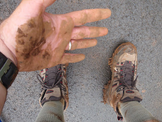
It rained a little bit on our way back down, and the trail toward the bottom got pretty slick and muddy.

I slipped.

I do NOT recommend climbing Olomana if it has rained recently or is expected to rain soon.

Overall, this was a most EXCELLENT adventure - great exercise with a great view.