When I sat down at my computer to do some research and figure out when and where to go, I was amazed by the size of the park. It's bigger than the state of Rhode Island for cryin' out loud (777,000 acres in RI vs. 922,000 acres in ONP). There are several different visitor centers at different places around the park. I get the impression that each one is strategically located to show a very different aspect of the park - sub-alpine versus rain forest versus coastal).
I decided to try Hurricane Ridge, at the Northern end of the park, about twenty miles south of Port Angeles, Washington. I could tell from the webcam that there is still snow up there (there's a second webcam on the parking lot), but I couldn't find any useful gouge on whether I would need snowshoes or not. The thought of renting snowshoes at Pacific Edge Outfitters again crossed my mind, but I remembered that the National Park visitor center on Mt. Rainier offered snow shoes for rent there. The ONP website said they had snowshoes to rent, so I figured I would drive up there and rent them if I needed them.
Scenery on the drive up from Port Angeles
Scenery on the drive up from Port Angeles
There was just a little bit of snow left over from "winter."
Well, come to find out, there are basically two seasons at Hurricane Ridge. During the winter season, they rent skis, sleds, snowshoes, and run a ski lift and have a big booming business. They even have park ranger led showshoe hikes. The "winter" season ends around mid March. Next, the "summer" season seems to start around mid July, and there are park ranger led hikes to admire beautiful flowers and stunning views.
Apparently though, if you go in between the end of "winter" and the beginning of "summer" then you pretty much get to make do on your own. Nothing is available to rent. No park rangers provide any guided hikes. It's all you.
Don't get me wrong. I had a great time, and I'm very glad I went. I was just surprised by the gap in activity offered at this park compared to most other national parks.
I had lunch in the visitor center cafe, and it was very good. Much better than the cafe at Mt. Rainier. I had a ham and swiss on rye with sweet potato fries and it was delicious.
This was the view I got to enjoy from the cafe while eating my lunch. Nope, no need to rent any showshoes or anything like that this time of year.
The park ranger at the visitor center told me they put out orange poles in the snow leading away from the parking lot to lead people to a scenic overlook. She told me the snow was packed down enough that I didn't need snowshoes.
Sure enough.
Oh, but don't walk past the LAST orange pole.
The view was indeed spectacular. The photo doesn't do it justice. In the foreground is Port Angeles, then the Strait of Juan de Fuca, then Victoria, British Columbia in the distance.
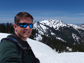
Obligatory Blunoz self-portrait
I hiked clockwise around the ridge. This is looking back at where those avalanche warning signs were.
See the signs?
Aside from walking the short distance along the orange poles from the visitor center to the view point, most people were just walking the plowed Hurricane Ridge Road. It was closed to vehicles and partially plowed, and it wound back and forth down the hill for a mile or so. The view was much better from up on top of the snow on either side of the road than it was from on the pavement. Since it was my first time there and I didn't have snowshoes or skis, I stayed close to the paved road. I did see some people showing up with their own snowshoes go trekking off into the snow though, and it made me wish I had my own.
For the portion of my hike that I did on the road, I kept thinking I was Luke Skywalker attacking the Death Star. Then I came to the end of where the plow had been...
Use the Force, Luke!
After crossing over to the south side of the road, I found an area where the snow had melted.
Over on this side of the ridge, I had several of these pretty birds following me along from tree to tree. I don't know if they were just naturally curious or if they've been fed by humans one too many times and were looking for a handout.
Overall, it was a gorgeous day, a very enjoyable drive, and a nice hike with stunning scenery. This will certainly not be my last time to visit ONP. Next time I'll just have to bring my own snowshoes, or come back in the summer season when the snow has melted.
Trip Stats on the GPS
Hike Stats:
Date: 4 June 2011
Start Time: 12:43 p.m.
Moving Time Elapsed: 1 hr 43 min
Stopped Time Elapsed: 30 min
Finish Time: 2:55 p.m.
Miles: 3.1 miles
Elevation gain: 443 feet
Temp: Began approx 57F climbing to 64F when I drove back down.
Wind: None.


That's some beautiful scenery, I can only imagine how great to witness firsthand! That stinks about the gap though.
ReplyDelete