After a brief stop in Portland, OR, we drove down to Sisters, OR for my step-brother's wedding on Saturday.
The scenery along the way was spectacular.
We stopped in Madras, OR and had some awesome burgers at this place...
The name of the milkshake flavor had me wondering if I'm going to pop-positive for cocaine on my next urinalysis. It was a darn good shake though. (It actually tasted sort of like blueberry.)
We got checked into our two rental houses at the Black Butte Ranch and had a wonderful family dinner last night.
Grandpa continued to enjoy MFA (Most Favored Adult) status.
I also got to indulge in a bottle of my favorite wine...
This morning, the boys were really excited by the four deer on our back porch looking for breakfast handouts.
 ES took this photo with his camera while standing at the edge of the deck. The deer came right up to the deck and ate out of Grandma's hand.
I took my dad and aunt out to find a geocache today. This one was a perfect example of why I love geocaching. It takes me to places I never would have gone to if it weren't for the geocache placed there.
I was panning across the map of nearby geocaches, and I saw this listing with "observatory" in the title, and saw that it was an Earth Cache (geology related, approved by the Geological Society of America). The description made it sound like a pretty good panoramic view of the area, and it was "only" 22 miles away, so I figured we'd give it a shot.
It felt like we were driving around the Big Island (Hawaii) because we were on these narrow roads winding through miles upon miles of barren volcanic wasteland. The geocache was at an "observatory", but not the type of observatory you would normally expect. This was just a spectacular view point to see several mountains in all directions.
Inside the "observatory" were a series of viewing windows. Each was carefully constructed to limit your view to a single mountain peak, and each window was labeled with what peak you were looking at and how far away it was.
 Windows for Mt. Jefferson and Mt. Hood
 Mt. Jefferson View through the Left Window Above
 Mt. Washington through Right Window Above
If you continue on up the volcanic rock steps around the outside of the observatory...
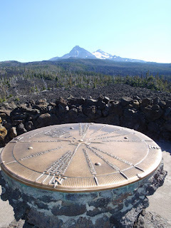
...on top of the structure you find this compass rose with pointers to each of the peaks in view.
 View on top of the Observatory looking North
(Mt. Washington on left and
Mt. Jefferson in distance just right of center)
 View on top of the Observatory looking South
(Three Sisters)
If you'd like to see a different view of the volcanic wasteland we were in, click here, then zoom out a few times. I wanted to copy and paste the image from Google Maps, but their Terms of Use prohibit any form of copying. Hopefully the link will work to take you there.
We had to high-tail it out of there. This geocache was 22 miles as the Google Maps drives, but I didn't anticipate the narrow, winding, switch-back roads at 20-30 mph, so we had to boogie to get back in time for the wedding rehearsal at Black Butte Ranch.
My wonderful wife got me an awesome new camera for my upcoming birthday, and it takes panorama photos. I tested out the panorama photo feature during the wedding rehearsal.


Any suggestions for a newbie geocacher GPS device?
ReplyDelete